IMAGES TAKEN NEAR TO
Longmanhill, BANFF, AB45 3RT
Introduction
This page details the photographs taken nearby to AB45 3RT by members of the Geograph project.
The Geograph project started in 2005 with the aim of publishing, organising and preserving representative images for every square kilometre of Great Britain, Ireland and the Isle of Man.

There are currently over 7.5m images from over14,400 individuals and you can help contribute to the project by visiting https://www.geograph.org.uk
Image Map
Images are licensed for reuse under creativecommons.org/licenses/by-sa/2.0
Notes
- Clicking on the map will re-center to the selected point.
- The higher the marker number, the further away the image location is from the centre of the postcode.
Image Listing (5 Images Found)
Images are licensed for reuse under creativecommons.org/licenses/by-sa/2.0
Image
Details
Distance
1
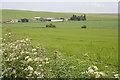
Hillside
Hillside Farm, admittedly built on a gentle slope, is actually right on the A98 trunk road, though happily that is less busy here than it is further west. Lush crops and this year's magnificent display of Hogweed (the ordinary native one, not the introduced giant version, but every bit as poisonous) provide a verdant foreground.
Image: © Anne Burgess
Taken: 5 Jul 2012
0.14 miles
2
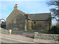
Longmanhill
Stone cottages line the main road in the hamlet of Longmanhill.
Image: © Anne Burgess
Taken: 19 Dec 2006
0.15 miles
4
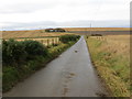
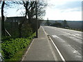
Minor road heading in the direction of Easter Headitown
Looking westward.
Image: © Peter Wood
Taken: 17 Nov 2019
0.22 miles