IMAGES TAKEN NEAR TO
BANFF, AB45 3QS
Introduction
This page details the photographs taken nearby to AB45 3QS by members of the Geograph project.
The Geograph project started in 2005 with the aim of publishing, organising and preserving representative images for every square kilometre of Great Britain, Ireland and the Isle of Man.

There are currently over 7.5m images from over14,400 individuals and you can help contribute to the project by visiting https://www.geograph.org.uk
Image Map
Images are licensed for reuse under creativecommons.org/licenses/by-sa/2.0
Notes
- Clicking on the map will re-center to the selected point.
- The higher the marker number, the further away the image location is from the centre of the postcode.
Image Listing (6 Images Found)
Images are licensed for reuse under creativecommons.org/licenses/by-sa/2.0
Image
Details
Distance
3
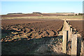
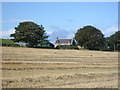
Near Backhill of Foulzie
Looking across ploughed fields near Backhill of Foulzie. Easter Montbellton, in the nezt square, is among the trees near the centre of the horizon.
Image: © Anne Burgess
Taken: 26 Feb 2013
0.19 miles
4
Croft of Newton of Foulzie
Sadly, there is not much left of Croft of Newton of Foulzie. It is not named on the modern maps, but it is on the Victorian six-inch ones.
Image: © Anne Burgess
Taken: 26 Feb 2013
0.22 miles
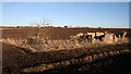
6
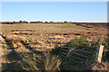
Rough Ground beside More Bridge
More Bridge carries the minor road over the Burn of Montbletton. At the top of the hill are some new houses around Croft of Bruntyards.
Image: © Anne Burgess
Taken: 26 Feb 2013
0.22 miles