IMAGES TAKEN NEAR TO
King Edward, BANFF, AB45 3PR
Introduction
This page details the photographs taken nearby to AB45 3PR by members of the Geograph project.
The Geograph project started in 2005 with the aim of publishing, organising and preserving representative images for every square kilometre of Great Britain, Ireland and the Isle of Man.

There are currently over 7.5m images from over14,400 individuals and you can help contribute to the project by visiting https://www.geograph.org.uk
Image Map
Images are licensed for reuse under creativecommons.org/licenses/by-sa/2.0
Notes
- Clicking on the map will re-center to the selected point.
- The higher the marker number, the further away the image location is from the centre of the postcode.
Image Listing (3 Images Found)
Images are licensed for reuse under creativecommons.org/licenses/by-sa/2.0
Image
Details
Distance
1
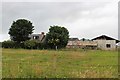
Broomhill Farm
Broomhill Farm near Gorrachie.
Image: © Andrew Wood
Taken: 21 Jul 2020
0.11 miles
2
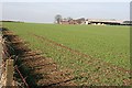
Broomhill
Next year's crop seems to be coming on well in this field at Broomhill. The farm itself is right on the gridline.
Image: © Anne Burgess
Taken: 24 Oct 2007
0.12 miles
3
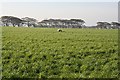
Near Gorrachie
The land rises gently from the road into the centre of this square, making it difficult to get an interesting view. The sheep have probably been brought down from high ground to winter in this field of grass.
Image: © Anne Burgess
Taken: 24 Oct 2007
0.22 miles