IMAGES TAKEN NEAR TO
King Edward, BANFF, AB45 3PD
Introduction
This page details the photographs taken nearby to AB45 3PD by members of the Geograph project.
The Geograph project started in 2005 with the aim of publishing, organising and preserving representative images for every square kilometre of Great Britain, Ireland and the Isle of Man.

There are currently over 7.5m images from over14,400 individuals and you can help contribute to the project by visiting https://www.geograph.org.uk
Image Map
Images are licensed for reuse under creativecommons.org/licenses/by-sa/2.0
Notes
- Clicking on the map will re-center to the selected point.
- The higher the marker number, the further away the image location is from the centre of the postcode.
Image Listing (5 Images Found)
Images are licensed for reuse under creativecommons.org/licenses/by-sa/2.0
Image
Details
Distance
1
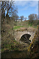
Castleton and the Old Bridge
The farm house of Castleton stands at the top of a steepish slope above the old bridge, built in 1771 and superseded just three decades later when the road was realigned.
Image: © Anne Burgess
Taken: 1 May 2013
0.16 miles
2
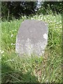
Old Milestone by the A947, Castleton, south of Banff
By the A947, in parish of King Edward (District), South of Castleton Farm, at 'Road Narrows' sign for bridge.
Inscription reads:-
6
(To Banff)
Surveyed
Milestone Society National ID: AD_BFTR06
Image: © Milestone Society
Taken: Unknown
0.21 miles
4
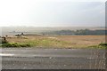
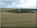
North Hollymill Farm is to the right of the track.
Image: © Des Colhoun
Taken: 13 Sep 2006
0.23 miles