IMAGES TAKEN NEAR TO
King Edward, BANFF, AB45 3NP
Introduction
This page details the photographs taken nearby to AB45 3NP by members of the Geograph project.
The Geograph project started in 2005 with the aim of publishing, organising and preserving representative images for every square kilometre of Great Britain, Ireland and the Isle of Man.

There are currently over 7.5m images from over14,400 individuals and you can help contribute to the project by visiting https://www.geograph.org.uk
Image Map
Images are licensed for reuse under creativecommons.org/licenses/by-sa/2.0
Notes
- Clicking on the map will re-center to the selected point.
- The higher the marker number, the further away the image location is from the centre of the postcode.
Image Listing (7 Images Found)
Images are licensed for reuse under creativecommons.org/licenses/by-sa/2.0
Image
Details
Distance
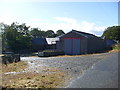
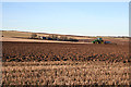
2
Muirton
The farm buildings at Muirton are partly concealed by the surrounding trees.
Image: © Anne Burgess
Taken: 24 Oct 2007
0.04 miles
3
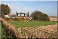
Muirton
A traditional sandstone farm house with its sheltering trees.
Image: © Anne Burgess
Taken: 24 Oct 2007
0.07 miles
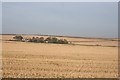
5
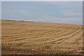
Gulls and Geese
For some reason, this stubble field seems to have attracted a large flock of gulls, and a large flock of Pink-Footed Geese above them.
Image: © Anne Burgess
Taken: 24 Oct 2007
0.23 miles
6
Ploughing near Gorrachie
The farm in the background is Muirton.
Image: © Anne Burgess
Taken: 26 Feb 2013
0.23 miles
7
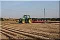
Ploughing near Fortrie
The tractor and plough provide a splash of colour in the near-monochrome landscape of stubble fields.
Image: © Anne Burgess
Taken: 24 Oct 2007
0.24 miles