IMAGES TAKEN NEAR TO
King Edward, BANFF, AB45 3NJ
Introduction
This page details the photographs taken nearby to AB45 3NJ by members of the Geograph project.
The Geograph project started in 2005 with the aim of publishing, organising and preserving representative images for every square kilometre of Great Britain, Ireland and the Isle of Man.

There are currently over 7.5m images from over14,400 individuals and you can help contribute to the project by visiting https://www.geograph.org.uk
Image Map
Images are licensed for reuse under creativecommons.org/licenses/by-sa/2.0
Notes
- Clicking on the map will re-center to the selected point.
- The higher the marker number, the further away the image location is from the centre of the postcode.
Image Listing (6 Images Found)
Images are licensed for reuse under creativecommons.org/licenses/by-sa/2.0
Image
Details
Distance
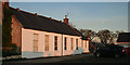
1
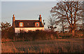
Blackton Cottage
The cottage is just beside the minor road to Bridgend, off the A947 at King Edward.
Image: © Anne Burgess
Taken: 7 Nov 2011
0.01 miles
2
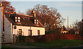
Croft of Danshillock
The croft house stands on the A947 at King Edward. To the right is Blackton Cottage, on the minor road to Bridgend.
Image: © Anne Burgess
Taken: 7 Nov 2011
0.06 miles
3
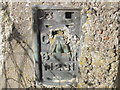
Ordnance Survey Flush Bracket 11231
This can be found on the wall of a building at Croft of Danshillock.
For more detail see : http://www.bench-marks.org.uk/bm21513
Image: © Peter Wood
Taken: 6 Oct 2012
0.06 miles
4
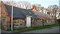
Old Buildings at King Edward
This long low row of sandstone buildings was probably part of a farm steading at one time, though it now seems to be in use as a shed or even sheds.
Image: © Anne Burgess
Taken: 7 Nov 2011
0.21 miles
5
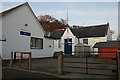
King Edward School
The older building, bearing the date 1910 above the door, is to the right, and the newer one to the left.
Image: © Anne Burgess
Taken: 7 Nov 2011
0.22 miles
6
King Edward School
This is the newer of the two buildings making up the primary school at King Edward, just off the A947.
Image: © Anne Burgess
Taken: 7 Nov 2011
0.25 miles