IMAGES TAKEN NEAR TO
BANFF, AB45 3JX
Introduction
This page details the photographs taken nearby to AB45 3JX by members of the Geograph project.
The Geograph project started in 2005 with the aim of publishing, organising and preserving representative images for every square kilometre of Great Britain, Ireland and the Isle of Man.

There are currently over 7.5m images from over14,400 individuals and you can help contribute to the project by visiting https://www.geograph.org.uk
Image Map
Images are licensed for reuse under creativecommons.org/licenses/by-sa/2.0
Notes
- Clicking on the map will re-center to the selected point.
- The higher the marker number, the further away the image location is from the centre of the postcode.
Image Listing (16 Images Found)
Images are licensed for reuse under creativecommons.org/licenses/by-sa/2.0
Image
Details
Distance
1
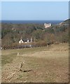
Kirkside and Duff House
The dramatic architecture of Duff House, in the next square, catches the eye and dominates the view from above Kirkside.
Image: © Anne Burgess
Taken: 19 Mar 2010
0.03 miles
2
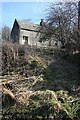
House at Kirkside
In summer, when all the vegetation has grown up again, this house will be well screened from the road.
Image: © Anne Burgess
Taken: 19 Mar 2010
0.07 miles
3
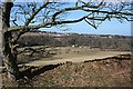
Banff from the Wood of Montcoffer
A long horizontal branch provides a frame for a view across the River Deveron of the burgh of Banff, which is in the next square. All of the foreground, including the trees beyond the river, is in square.
Image: © Anne Burgess
Taken: 19 Mar 2010
0.07 miles
4
Kirkside
The trees make such a good job of obscuring the view from the riverside paths that only where the power lines cross the river is it possible to see Kirkside Farm.
Image: © Anne Burgess
Taken: 11 Feb 2008
0.11 miles
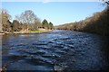
5
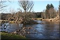
Scury Island
This is the downstream tip of the Scury Islands, which divide the river channel in two upstream of here. In the foreground are branches festooned with debris brought down in the recent spate.
Image: © Anne Burgess
Taken: 19 Mar 2010
0.13 miles
6
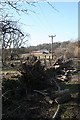
Hedgerow Maintenance
Some of the trees in the hedgerow have been cut well back. The stumps will soon produce dense young growth closer to the ground and safely out of reach of the overhead power line.
Image: © Anne Burgess
Taken: 19 Mar 2010
0.14 miles
7
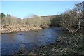
River Deveron
This is not the full width of the river; the ground on the left is one of the islands in the river channel.
Image: © Anne Burgess
Taken: 19 Mar 2010
0.15 miles
8
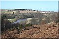
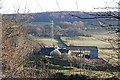
River Deveron
Looking down from Montcoffer Hill to the River Deveron. The outskirts of Banff are to the right.
Image: © Anne Burgess
Taken: 19 Mar 2010
0.18 miles
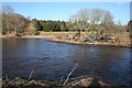
9
River Deveron
This is the full width of the river, the channels having amalgamated downstream of the Scury Islands.
Image: © Anne Burgess
Taken: 19 Mar 2010
0.18 miles
10
River Deveron
Looking across the island in mid-river from the bank near Kirkside. On the far bank is Duff House Royal Golf Course.
Image: © Anne Burgess
Taken: 19 Mar 2010
0.19 miles