IMAGES TAKEN NEAR TO
BANFF, AB45 3ES
Introduction
This page details the photographs taken nearby to AB45 3ES by members of the Geograph project.
The Geograph project started in 2005 with the aim of publishing, organising and preserving representative images for every square kilometre of Great Britain, Ireland and the Isle of Man.

There are currently over 7.5m images from over14,400 individuals and you can help contribute to the project by visiting https://www.geograph.org.uk
Image Map
Images are licensed for reuse under creativecommons.org/licenses/by-sa/2.0
Notes
- Clicking on the map will re-center to the selected point.
- The higher the marker number, the further away the image location is from the centre of the postcode.
Image Listing (6 Images Found)
Images are licensed for reuse under creativecommons.org/licenses/by-sa/2.0
Image
Details
Distance
1
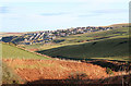
Gardenstown to the northeast of Den of Afforsk
Image: © Des Colhoun
Taken: 26 Nov 2006
0.04 miles
2
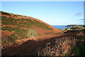
Looking seaward along the Den of Afforsk.
The Kirk Burn runs along the depression to the left.
Image: © Des Colhoun
Taken: 26 Nov 2006
0.08 miles
3
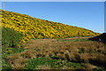
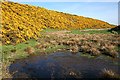
Den of Afforsk
Compare with Image], taken nine years earlier when the whins were in similar bloom, but note that the pond has dried up.
Image: © Anne Burgess
Taken: 29 Apr 2019
0.14 miles
4
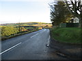
Road (B9031) at Greenskares
Looking north-eastward
Image: © Peter Wood
Taken: 17 Nov 2019
0.16 miles
5
Afforsk
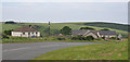
Apart from one wall, all the old buildings at Afforsk have been replaced by new houses, complete with solar panel arrays. The road is the B9031.
Image: © Anne Burgess
Taken: 5 Jul 2012
0.17 miles
6
Bog of Minnonie
Although separated only by the road from the Den of Afforsk, this marshy patch seems to drain in the opposite direction, towards the Bog of Minnonie. The whins make a fine show in late spring. Compare with Image], taken nine years later.
Image: © Anne Burgess
Taken: 31 May 2010
0.19 miles