
IMAGES TAKEN NEAR TO
BANFF, AB45 2YP
Introduction
This page details the photographs taken nearby to AB45 2YP by members of the Geograph project.
The Geograph project started in 2005 with the aim of publishing, organising and preserving representative images for every square kilometre of Great Britain, Ireland and the Isle of Man.

There are currently over 7.5m images from over14,400 individuals and you can help contribute to the project by visiting https://www.geograph.org.uk
Image Map
Images are licensed for reuse under creativecommons.org/licenses/by-sa/2.0
Notes
- Clicking on the map will re-center to the selected point.
- The higher the marker number, the further away the image location is from the centre of the postcode.
Image Listing (4 Images Found)
Images are licensed for reuse under creativecommons.org/licenses/by-sa/2.0
Image
Details
Distance
1
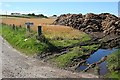
Wellheads
The waterlogged ruts are evidence that the last couple of weeks here have been fairly wet, unlike the south of Britain where there have been near-drought conditions. Wellheads Farm is at the top of the brae.
Image: © Anne Burgess
Taken: 5 Aug 2010
0.02 miles

4
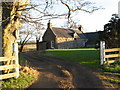
Auchanachie Farm
This is Auchanachie House near Tillynaught. It was originally the farmhouse of Auchanachie Farm, the farm having been owned until about 1960 by Seafield Estates. Thereafter it passed into private ownership, most recently about 12 years ago.
Image: © Christopher Gillan
Taken: 14 Nov 2006
0.25 miles