IMAGES TAKEN NEAR TO
BANFF, AB45 2XB
Introduction
This page details the photographs taken nearby to AB45 2XB by members of the Geograph project.
The Geograph project started in 2005 with the aim of publishing, organising and preserving representative images for every square kilometre of Great Britain, Ireland and the Isle of Man.

There are currently over 7.5m images from over14,400 individuals and you can help contribute to the project by visiting https://www.geograph.org.uk
Image Map
Images are licensed for reuse under creativecommons.org/licenses/by-sa/2.0
Notes
- Clicking on the map will re-center to the selected point.
- The higher the marker number, the further away the image location is from the centre of the postcode.
Image Listing (4 Images Found)
Images are licensed for reuse under creativecommons.org/licenses/by-sa/2.0
Image
Details
Distance
1
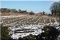
Little Toux
There are two access roads to Little Toux. This is taken from beside the more westerly approach road.
Image: © Anne Burgess
Taken: 23 Feb 2010
0.01 miles
2
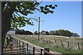
Little Toux
The farm house is sheltered by the traditional clump of trees to break the force of winter gales from the north and west.
Image: © Anne Burgess
Taken: 30 Apr 2007
0.02 miles
3
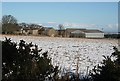
Little Toux
Some of the numerous barns and byres here have seen better days.
Image: © Anne Burgess
Taken: 23 Feb 2010
0.05 miles
4
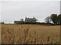
Little Toux
See comment in relation to Meikle Toux!!!!
Image: © Christopher Gillan
Taken: 7 Nov 2006
0.05 miles