IMAGES TAKEN NEAR TO
Fordyce, BANFF, AB45 2XA
Introduction
This page details the photographs taken nearby to AB45 2XA by members of the Geograph project.
The Geograph project started in 2005 with the aim of publishing, organising and preserving representative images for every square kilometre of Great Britain, Ireland and the Isle of Man.

There are currently over 7.5m images from over14,400 individuals and you can help contribute to the project by visiting https://www.geograph.org.uk
Image Map
Images are licensed for reuse under creativecommons.org/licenses/by-sa/2.0
Notes
- Clicking on the map will re-center to the selected point.
- The higher the marker number, the further away the image location is from the centre of the postcode.
Image Listing (4 Images Found)
Images are licensed for reuse under creativecommons.org/licenses/by-sa/2.0
Image
Details
Distance
1
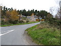
Birch Villa
House and Farm buildings
Image: © Christopher Gillan
Taken: 7 Nov 2006
0.13 miles
3
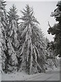
Snowy Spruce
This snowfall caused a significant amount of damage, with numerous branches torn off the trees, this spruce stood up well though!
Image: © Will Anderson
Taken: 6 Feb 2009
0.23 miles
4
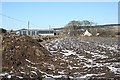
Burnside
The house is on the east side of the road and the farm buildings on the west. This is taken from the edge of a field beside the road.
Image: © Anne Burgess
Taken: 23 Feb 2010
0.24 miles