IMAGES TAKEN NEAR TO
The Bents, BANFF, AB45 2UF
Introduction
This page details the photographs taken nearby to The Bents, AB45 2UF by members of the Geograph project.
The Geograph project started in 2005 with the aim of publishing, organising and preserving representative images for every square kilometre of Great Britain, Ireland and the Isle of Man.

There are currently over 7.5m images from over14,400 individuals and you can help contribute to the project by visiting https://www.geograph.org.uk
Image Map
Images are licensed for reuse under creativecommons.org/licenses/by-sa/2.0
Notes
- Clicking on the map will re-center to the selected point.
- The higher the marker number, the further away the image location is from the centre of the postcode.
Image Listing (15 Images Found)
Images are licensed for reuse under creativecommons.org/licenses/by-sa/2.0
Image
Details
Distance
1
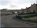
The Bents, Sandend
Small modern housing development at Sandend.
Image: © Christopher Gillan
Taken: 16 Nov 2006
0.07 miles
2
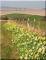
Sandend
A bank of daffodils greets motorists on the road into Sandend.
Image: © Anne Burgess
Taken: 26 Mar 2007
0.09 miles
3
Sandend Bridge.
Houses situated at Sandend Bridge between Sandend and the main road.
Image: © Christopher Gillan
Taken: 12 Apr 2006
0.10 miles
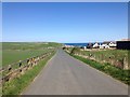
4
Near Mains of Glassaugh, looking towards Sandend
Image: © Astrid H
Taken: 19 Jun 2011
0.14 miles
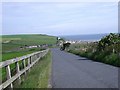
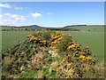
6
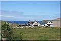
Linkbraeheads
Linkbraeheads stands between the A98 trunk road and the line of the former Great North of Scotland Railway. In the distance is a glimpse of the village of Sandend, which is in the next square.
Image: © Anne Burgess
Taken: 5 Aug 2010
0.17 miles
7
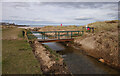
Bridge to Sandend Beach
A footbridge over the Scattery Burn, from Sandend Caravan Park to Sandend Beach.
Image: © Craig Wallace
Taken: 26 Feb 2022
0.19 miles
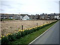
8
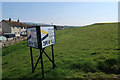
Land for sale, Sandend
2.2 acres of residential development land.
Image: © Hugh Venables
Taken: 22 Apr 2019
0.21 miles
10
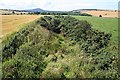
Former GNSR Railway Line
Looking west from the overbridge at Mains of Glassaugh, this is a cutting on the route of the former Great North of Scotland railway. The hill in the distance is the Bin of Cullen.
Image: © Anne Burgess
Taken: 5 Aug 2010
0.23 miles