IMAGES TAKEN NEAR TO
Portsoy, BANFF, AB45 2TB
Introduction
This page details the photographs taken nearby to AB45 2TB by members of the Geograph project.
The Geograph project started in 2005 with the aim of publishing, organising and preserving representative images for every square kilometre of Great Britain, Ireland and the Isle of Man.

There are currently over 7.5m images from over14,400 individuals and you can help contribute to the project by visiting https://www.geograph.org.uk
Image Map
Images are licensed for reuse under creativecommons.org/licenses/by-sa/2.0
Notes
- Clicking on the map will re-center to the selected point.
- The higher the marker number, the further away the image location is from the centre of the postcode.
Image Listing (6 Images Found)
Images are licensed for reuse under creativecommons.org/licenses/by-sa/2.0
Image
Details
Distance
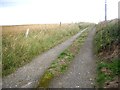
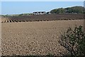
1
Farming at Cowhythe
The cottages in the distance include Cowhythe Cottage. I think the machinery attached to the tractor is a plough
Image: © Anne Burgess
Taken: 9 May 2008
0.02 miles
3
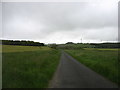
Minor road heading east from Portsoy
This is shown on my map as the B9139, but I think that an alternative route a bit further south has now been classified as such.
Image: © David Purchase
Taken: 11 Jun 2019
0.11 miles
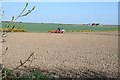
4

Cowhythe, Portsoy
Oilseed rape awaits the combine harvester
Image: © Anne Burgess
Taken: Unknown
0.20 miles
5
Cowhythe Farm
I presume that the deep furrows are for tatties (potatoes).
Image: © Anne Burgess
Taken: 9 May 2008
0.20 miles