IMAGES TAKEN NEAR TO
Portsoy, BANFF, AB45 2TA
Introduction
This page details the photographs taken nearby to AB45 2TA by members of the Geograph project.
The Geograph project started in 2005 with the aim of publishing, organising and preserving representative images for every square kilometre of Great Britain, Ireland and the Isle of Man.

There are currently over 7.5m images from over14,400 individuals and you can help contribute to the project by visiting https://www.geograph.org.uk
Image Map
Images are licensed for reuse under creativecommons.org/licenses/by-sa/2.0
Notes
- Clicking on the map will re-center to the selected point.
- The higher the marker number, the further away the image location is from the centre of the postcode.
Image Listing (13 Images Found)
Images are licensed for reuse under creativecommons.org/licenses/by-sa/2.0
Image
Details
Distance
2
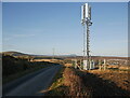
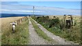
Mobile phone mast, by the B9139
Overlooking Portsoy, next to the track off to Rosehall. The mast is operated by O2 and Vodafone.
Image: © Craig Wallace
Taken: 27 Feb 2022
0.07 miles
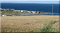
3
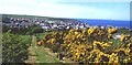
A view of Seatown, Portsoy
From B9139, near Longside
Image: © Stanley Howe
Taken: 30 Aug 2012
0.07 miles
4
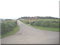
Barley, Hillhead
A field of barley overlooking Portsoy.
Image: © Richard Webb
Taken: 5 Aug 2011
0.09 miles
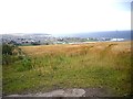
7
Wheat, Portsoy
A view across the Moray Firth from the B9139 above Portsoy.
Image: © Richard Webb
Taken: 5 Aug 2011
0.13 miles
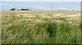
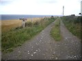
9
Portsoy
There are plenty of interesting walks around the small town of Portsoy
Image: © Anne Burgess
Taken: Unknown
0.14 miles
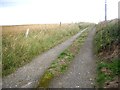
10
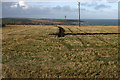
The first furrow
Starting to plough field.
Looking W from position
Image: © Iain Macaulay
Taken: 16 Nov 2005
0.14 miles