IMAGES TAKEN NEAR TO
Castle Lane, BANFF, AB45 2SE
Introduction
This page details the photographs taken nearby to Castle Lane, AB45 2SE by members of the Geograph project.
The Geograph project started in 2005 with the aim of publishing, organising and preserving representative images for every square kilometre of Great Britain, Ireland and the Isle of Man.

There are currently over 7.5m images from over14,400 individuals and you can help contribute to the project by visiting https://www.geograph.org.uk
Image Map
Images are licensed for reuse under creativecommons.org/licenses/by-sa/2.0
Notes
- Clicking on the map will re-center to the selected point.
- The higher the marker number, the further away the image location is from the centre of the postcode.
Image Listing (69 Images Found)
Images are licensed for reuse under creativecommons.org/licenses/by-sa/2.0
Image
Details
Distance
1
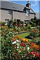
Garden in Fordyce
This magnificent and colourful garden on Church Street is a delight to the eye of every passer-by
Image: © Anne Burgess
Taken: 5 Aug 2010
0.02 miles
2
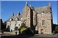
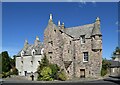
Fordyce Castle
The castle dates from 1592, with additions in 1700. It was built by Thomas Menzies of Durn, and is Category A Listed.
Image: © Anne Burgess
Taken: 11 May 2022
0.02 miles
3
Fordyce Castle
Tower house, dated 1592, with north wing to left added c.1700. Listed Category A. The feeling of general unrest at the time of building is testified to by numerous gunloops in all parts of the older section.
Image: © Alan Murray-Rust
Taken: 23 May 2022
0.02 miles
4
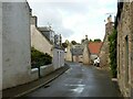
East Church Street
The road out of the village towards Portsoy.
Image: © Anne Burgess
Taken: 2 Jul 2007
0.02 miles
5
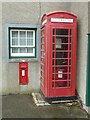
Telephone kiosk and postbox, Fordyce
The kiosk is a standard K6 version, and is now Listed Category C.
The postbox is an early George V wall box, using the same pattern as the previous reign. The design would later be revised with the cipher on the door and a plainer posting slot https://www.geograph.org.uk/photo/3933347
Image: © Alan Murray-Rust
Taken: 23 May 2022
0.02 miles
6
Fordyce, July 1992
The castle is visible in the background.
Image: © Alan O'Dowd
Taken: Unknown
0.02 miles
7
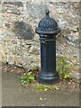
Public water supply, Fordyce
Later 19th century cast iron water fountain by Glenfield and Kennedy to a standard design widely used in Britain. Listed Category B, where it is described as a pump, but there would be no pump mechanism, the water being supplied by pipe from a supply main.
Image: © Alan Murray-Rust
Taken: 23 May 2022
0.02 miles
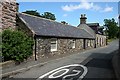
8
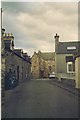
Church Street, Fordyce
Unmistakably Scottish! Most of the buildings are Listed.
Image: © Alan Murray-Rust
Taken: 23 May 2022
0.03 miles
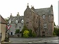
9
Fordyce Castle
The spectacular tower house in the middle of the village dates from 1592 and is A-listed: LB10623 http://portal.historicenvironment.scot/designation/LB10623 . The pump on the pavement has its own B-listing (LB10624 http://portal.historicenvironment.scot/designation/LB10624 ).
Image: © Bill Harrison
Taken: 10 Aug 2022
0.03 miles
10
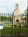
Fordyce Old Church (St Tarquin) ? 1
The gateway into the churchyard.
The churchyard and all the surviving elements of the church are a Scheduled Monument.
Image: © Alan Murray-Rust
Taken: 23 May 2022
0.03 miles