IMAGES TAKEN NEAR TO
Wood Street, BANFF, AB45 2RU
Introduction
This page details the photographs taken nearby to Wood Street, AB45 2RU by members of the Geograph project.
The Geograph project started in 2005 with the aim of publishing, organising and preserving representative images for every square kilometre of Great Britain, Ireland and the Isle of Man.

There are currently over 7.5m images from over14,400 individuals and you can help contribute to the project by visiting https://www.geograph.org.uk
Image Map
Images are licensed for reuse under creativecommons.org/licenses/by-sa/2.0
Notes
- Clicking on the map will re-center to the selected point.
- The higher the marker number, the further away the image location is from the centre of the postcode.
Image Listing (253 Images Found)
Images are licensed for reuse under creativecommons.org/licenses/by-sa/2.0
Image
Details
Distance
1
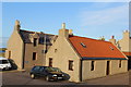
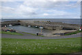
Cottages, Portsoy
Wood Street & Main Street
Image: © Leslie Barrie
Taken: 19 Jun 2013
0.01 miles
2
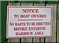
A sign that should not be necessary
You would have thought, or at least I would have thought, that people towing boats on trailers towards harbours would have enough sense not to step their masts before they get there. And even if they are daft enough and have managed to avoid all the low bridges and power lines put there to catch them out, isn't it a bit late to tell them as they enter the harbour area?
Image: © Anne Burgess
Taken: 5 Apr 2015
0.04 miles
3
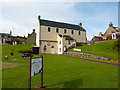
Portsoy Salmon Bothy
"The Salmon House was purpose built in 1834 by the Seafield Estate, which then owned the salmon fishing rights along the coast. The three story building provided an office, a bothy, an ice house, a fish preparation area, workshop and storage accommodation.
The stake-net salmon fishing began at a Station near to the mouth of the Burn of the Boyne as early as 1828. Bag-net fishing was also carried out. Abundant supplies of ice were obtained originally from Loch Soy and the Millpond and brought in by horse and cart.
The Salmon House continued in use until 1990, when salmon netting was stopped at the Portsoy Station. Salmon fishing therefore played a major part in the history of fishing in our area. (Extracts from Findlay Pirie's "History of Salmon Fishing")"
notes from http://www.salmonbothy.org.uk/index.html
Image: © Peter Barr
Taken: 13 Sep 2011
0.04 miles
4
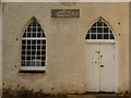
The Portsoy Salmon Bothy, front door
"The Salmon House was purpose built in 1834 by the Seafield Estate, which then owned the salmon fishing rights along the coast. The three story building provided an office, a bothy, an ice house, a fish preparation area, workshop and storage accommodation.
The stake-net salmon fishing began at a Station near to the mouth of the Burn of the Boyne as early as 1828. Bag-net fishing was also carried out. Abundant supplies of ice were obtained originally from Loch Soy and the Millpond and brought in by horse and cart.
The Salmon House continued in use until 1990, when salmon netting was stopped at the Portsoy Station. Salmon fishing therefore played a major part in the history of fishing in our area. (Extracts from Findlay Pirie's "History of Salmon Fishing")"
notes from http://www.salmonbothy.org.uk/index.html
Image: © Peter Barr
Taken: 13 Sep 2011
0.04 miles
5
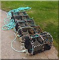
Lobster Pots, Portsoy
On New Harbour wall.
Image: © Stanley Howe
Taken: 23 Jul 2015
0.04 miles
6
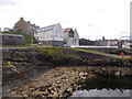
Residential flats, Portsoy
On Shore Street; seen from New Harbour wall.
Image: © Stanley Howe
Taken: 23 Jul 2015
0.04 miles
7
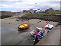
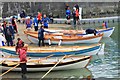
Small boats beached at their moorings in Portsoy New Harbour
The 20' Dipper Lug 'Black Gold' on the left, was built in Portsoy in 2000. Emmaley (BF777) was built 2010, and is a fishing vessel using pots and traps.
Image: © Stanley Howe
Taken: 23 Jul 2015
0.04 miles
9
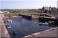
Portsoy Harbour
Showing the new harbour.
Image: © Stephen McKay
Taken: 28 May 2011
0.05 miles
10
New Harbour Skiffs
Contestants busy preparing their skiffs at the east end of the new harbour.
Image: © Andrew Wood
Taken: 25 Jun 2016
0.05 miles