IMAGES TAKEN NEAR TO
Aird Street, BANFF, AB45 2RB
Introduction
This page details the photographs taken nearby to Aird Street, AB45 2RB by members of the Geograph project.
The Geograph project started in 2005 with the aim of publishing, organising and preserving representative images for every square kilometre of Great Britain, Ireland and the Isle of Man.

There are currently over 7.5m images from over14,400 individuals and you can help contribute to the project by visiting https://www.geograph.org.uk
Image Map
Images are licensed for reuse under creativecommons.org/licenses/by-sa/2.0
Notes
- Clicking on the map will re-center to the selected point.
- The higher the marker number, the further away the image location is from the centre of the postcode.
Image Listing (101 Images Found)
Images are licensed for reuse under creativecommons.org/licenses/by-sa/2.0
Image
Details
Distance
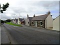
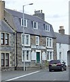
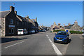
2
Banff Road
Most of these cottages on the road to Banff are built with gables to the street.
Image: © Anne Burgess
Taken: 9 May 2008
0.03 miles
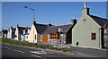
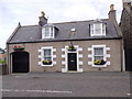
3
Banff Road
A traditional cottage, with a Victorian villa next door.
Image: © Anne Burgess
Taken: 9 May 2008
0.06 miles
4
Ordnance Survey Cut Mark
This mark can be found on the wall of a former hotel in Seafield Street.
For more detail see : http://www.bench-marks.org.uk/bm45907
Image: © Peter Wood
Taken: 5 Oct 2012
0.08 miles
5
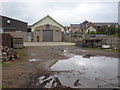
Portsoy 1st railway station (site), Aberdeenshire
Opened in 1859 by the Banff Portsoy & Strathisla Railway, later part of the Great North of Scotland Railway, as the terminus of its short branch from Tillynaught, this station closed to passengers in 1884 when it was replaced by the 2nd station some 200m to the south. The 1st station continued for goods, probably until the railway closed in 1968 (needs confirmation).
View north towards the buffers. Hidden by the later shed on the left is the still extant station building. Until 1910, a steep goods line ran past the right hand side of the trainshed, down to Portsoy harbour.
The site was used as a council recycling yard when this image was taken. Being mostly wooden, this is a remarkable survivor from 1859.
Image: © Nigel Thompson
Taken: 5 Sep 2019
0.08 miles
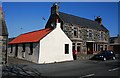
6
Wilkies Emporium, Portsoy
On the corner of Seafield Street (A98) and Schoolhendry Street (B9019)
Image: © Stanley Howe
Taken: 23 Jul 2015
0.08 miles
7
A former rail spur from the harbour
Having passed beneath Seafield Street towards the former Portsoy Station.
Image: © Stanley Howe
Taken: 23 Jul 2015
0.08 miles
8
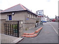
Public Toilets, Portsoy
Near the junction of Seafield Street (A98) and Schoolhendry Street (B9019).
Image: © Stanley Howe
Taken: 23 Jul 2015
0.09 miles
10
A cottage on the A98 through Portsoy
#27 Seafield Street, AB45 2QT.
Image: © Stanley Howe
Taken: 23 Jul 2015
0.10 miles