IMAGES TAKEN NEAR TO
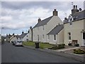
Burnside Court, BANFF, AB45 2QZ
Introduction
This page details the photographs taken nearby to Burnside Court, AB45 2QZ by members of the Geograph project.
The Geograph project started in 2005 with the aim of publishing, organising and preserving representative images for every square kilometre of Great Britain, Ireland and the Isle of Man.

There are currently over 7.5m images from over14,400 individuals and you can help contribute to the project by visiting https://www.geograph.org.uk
Image Map
Images are licensed for reuse under creativecommons.org/licenses/by-sa/2.0
Notes
- Clicking on the map will re-center to the selected point.
- The higher the marker number, the further away the image location is from the centre of the postcode.
Image Listing (325 Images Found)
Images are licensed for reuse under creativecommons.org/licenses/by-sa/2.0
Image
Details
Distance
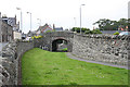
1
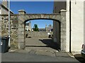
Archway on Culbert Street
Attached to the corner house https://www.geograph.org.uk/photo/7190874 , probably c.1830 also, and included in its Listing.
Image: © Alan Murray-Rust
Taken: 23 May 2022
0.03 miles
2
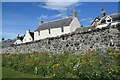
Wildflowers by the wall, Portsoy
54 Church Street on the other side of the wall dates from the late 18th Century and is C-listed (LB40229 http://portal.historicenvironment.scot/designation/LB40229 ).
Image: © Bill Harrison
Taken: 10 Aug 2022
0.03 miles
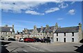
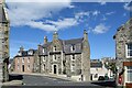
3
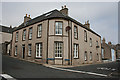
Corner of Culbert Street and Low Street
The curved corner of this building recalls the corner buildings of the Square in Cullen, and may be the work of William Robertson.
Image: © Anne Burgess
Taken: 22 Jul 2014
0.03 miles
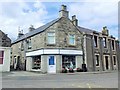
4
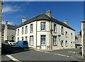
House on the corner of Culbert and Low Streets, Portsoy
Originally a single house, c.1830, style of William Robertson, architect, Elgin, the slightly recessed rounded corner being distinctive. Probably incorporating earlier work, Listed Category B. Now converted to flats.
Image: © Alan Murray-Rust
Taken: 23 May 2022
0.03 miles
5
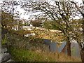
Site of the former mill
A water powered mill, mainly for the making of bone meal, once stood on this site; then, in the 1940s a larger building with oil powered machinery. Now demolished.
Image: © Peter Barr
Taken: 13 Sep 2011
0.04 miles
6
Former Railway Bridge
A branch line carved its way through the old town, terminating where I am standing. The former trackbed is now a path.
Image: © Anne Burgess
Taken: 22 Jul 2014
0.04 miles
8
Charity Shop, The Square, Portsoy
#5 The Square, AB45 2NX. A Masonic Hall to the right.
Image: © Stanley Howe
Taken: 23 Jul 2015
0.04 miles
10
The Boyne Hotel, The Square, Portsoy
The hotel just scrapes a C-listing (LB40264 http://portal.historicenvironment.scot/designation/LB40264 ) for its frontage whereas 4 North High Street to its left is B-listed (LB40265 http://portal.historicenvironment.scot/designation/LB40265 ).
Image: © Bill Harrison
Taken: 10 Aug 2022
0.04 miles