IMAGES TAKEN NEAR TO
Soy Avenue, BANFF, AB45 2QY
Introduction
This page details the photographs taken nearby to Soy Avenue, AB45 2QY by members of the Geograph project.
The Geograph project started in 2005 with the aim of publishing, organising and preserving representative images for every square kilometre of Great Britain, Ireland and the Isle of Man.

There are currently over 7.5m images from over14,400 individuals and you can help contribute to the project by visiting https://www.geograph.org.uk
Image Map
Images are licensed for reuse under creativecommons.org/licenses/by-sa/2.0
Notes
- Clicking on the map will re-center to the selected point.
- The higher the marker number, the further away the image location is from the centre of the postcode.
Image Listing (66 Images Found)
Images are licensed for reuse under creativecommons.org/licenses/by-sa/2.0
Image
Details
Distance

2
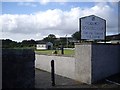
Access to Portsoy Bowling Club
Dress Code: Pin-stripe suit and rolled umbrella etc? [Bowlers welcome]
Image: © Stanley Howe
Taken: 30 Aug 2012
0.08 miles
3
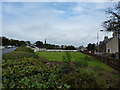
Bowling club, Portsoy
Once the site of Portsoy Tennis Club; not so energetic these days perhaps?
At the corner of Durn Road.
Image: © Peter Barr
Taken: 13 Sep 2011
0.08 miles
5
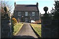
Georgian House
This house is just by the main road opposite the parish kirk. It is a little gem of Georgian style.
Image: © Anne Burgess
Taken: 11 Feb 2008
0.13 miles
6

Finial at No 7
The finials on the gateposts at No 7 (the Georgian house) are carved with foliage. Sadly the soft stone is starting to weather on top, where it is more exposed.
Image: © Anne Burgess
Taken: 11 Feb 2008
0.13 miles
7
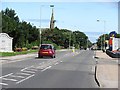
Seafield Terrace
Western approach to Portsoy.
Image: © Richard Webb
Taken: 5 Aug 2011
0.14 miles
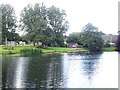
8
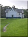
Former Railway Station, Portsoy
Retained as a Scout Hut and park feature by Loch Soy.
Image: © Stanley Howe
Taken: 30 Aug 2012
0.14 miles
9
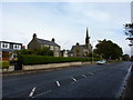
Seafield Terrace, Portsoy, with parish church
"Until 1741 the inhabitants of Portsoy belonging to the established Church attended public worship at the Parish Church of Fordyce.
This was felt to be a serious inconvenience especially in winter, the distance being two miles and the roads far from good.
The first Presbyterian place of worship was opened in 1741... situated in the back street nearly opposite to the Burnside distillery. Then in 1746 a new church, which was abandoned in 1804. Funds were raised for the present church in 1815, which accommodates up to 700 souls.
Image: © Peter Barr
Taken: 13 Sep 2011
0.14 miles
10
Portsoy 2nd railway station (site), Aberdeenshire
Opened in 1884 by the Great North of Scotland Railway on the line from Tillynaught to Tochieneal, extended 2 years later to Elgin, this through station replaced an earlier 1859 terminus some 200m to the north. In turn, this station closed in 1968.
View south east along the former platform towards Tillynaught and ultimately, Aberdeen. A second platform for westbound trains had existed to the right of the image. The station building was in use as a scout hut when this image was taken.
Image: © Nigel Thompson
Taken: 5 Sep 2019
0.14 miles