IMAGES TAKEN NEAR TO
Low Shore, BANFF, AB45 2NN
Introduction
This page details the photographs taken nearby to Low Shore, AB45 2NN by members of the Geograph project.
The Geograph project started in 2005 with the aim of publishing, organising and preserving representative images for every square kilometre of Great Britain, Ireland and the Isle of Man.

There are currently over 7.5m images from over14,400 individuals and you can help contribute to the project by visiting https://www.geograph.org.uk
Image Map
Images are licensed for reuse under creativecommons.org/licenses/by-sa/2.0
Notes
- Clicking on the map will re-center to the selected point.
- The higher the marker number, the further away the image location is from the centre of the postcode.
Image Listing (71 Images Found)
Images are licensed for reuse under creativecommons.org/licenses/by-sa/2.0
Image
Details
Distance
1
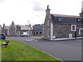
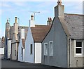
Seafront cottages on the Low Shore, Westhills
With their gable ends pointing towards the sea (off left) to counter offshore gales.
Image: © Stanley Howe
Taken: 23 Jul 2015
0.01 miles
2
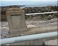
Whitehills, steps to the beach
A wider angle showing the location of the rivet and cutmark on top of Whitehills sea wall. It is located on the eastern side of the steps which lead to the beach. The rivet is easy to see, although the benchmark is a little worn.
Image: © Mel Towler
Taken: 2 Jul 2021
0.01 miles
3
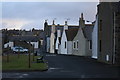
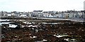
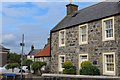
Whitehills housing
Housing in Whitehills next to the sea.
Image: © Colin Kinnear
Taken: 12 Jan 2012
0.02 miles
4
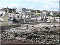
Whitehills
Houses gable on to the sea as is usual on the Moray Firth.
Image: © Richard Webb
Taken: 5 Aug 2011
0.02 miles
5
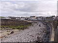
Low Shore beach, Westhills
An exposed outflow pipe can be seen entering the Moray Firth from the beach in the middle distance.
Image: © Stanley Howe
Taken: 23 Jul 2015
0.03 miles
6
Whitehills
A fishing village of traditional cottages, not yet spoilt by unsympathetic council housing or modern buildings.
Image: © Anne Burgess
Taken: 22 Aug 2006
0.05 miles
7
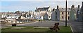
Whitehills
Cottages built in traditional style with gable ends facing the sea. The bench stands on a grassy area which would originally have been used for drying fishing nets.
Image: © Anne Burgess
Taken: 22 Aug 2006
0.05 miles
8
Gables
Gables facing the sea to offer some protection from northerly gales. Originally there would not have been windows in the gable ends.
Image: © Anne Burgess
Taken: 22 Aug 2006
0.05 miles
9

Whitehills, steps to the beach
The rivet and cutmark are on top of Whitehills sea wall. It is located on the eastern side of the steps to the beach. The rivet is easy to see, although the benchmark is a little worn.
Image: © Mel Towler
Taken: 2 Jul 2021
0.05 miles
10
House in Whitehills
On Seafield Street opposite Loch Street. Bears the date-stone 1794.
Image: © Leslie Barrie
Taken: 19 Jun 2013
0.08 miles