IMAGES TAKEN NEAR TO
Boyndie, BANFF, AB45 2LS
Introduction
This page details the photographs taken nearby to AB45 2LS by members of the Geograph project.
The Geograph project started in 2005 with the aim of publishing, organising and preserving representative images for every square kilometre of Great Britain, Ireland and the Isle of Man.

There are currently over 7.5m images from over14,400 individuals and you can help contribute to the project by visiting https://www.geograph.org.uk
Image Map
Images are licensed for reuse under creativecommons.org/licenses/by-sa/2.0
Notes
- Clicking on the map will re-center to the selected point.
- The higher the marker number, the further away the image location is from the centre of the postcode.
Image Listing (2 Images Found)
Images are licensed for reuse under creativecommons.org/licenses/by-sa/2.0
Image
Details
Distance
1
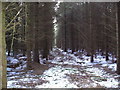
Within the Wood
A view along an extraction rack showing the detail of the tree crop. A "rack" is a term for an access within the woodland cut to allow machinery in to harvest and extract timber.
Image: © Will Anderson
Taken: 9 Feb 2008
0.20 miles
2
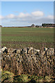
Rowanbrae
Fields planted with brassica, probably winter rape, with the buildings at Rowanbrae in the distance.
Image: © Anne Burgess
Taken: 17 Feb 2011
0.22 miles