IMAGES TAKEN NEAR TO
Boyndie, BANFF, AB45 2LL
Introduction
This page details the photographs taken nearby to AB45 2LL by members of the Geograph project.
The Geograph project started in 2005 with the aim of publishing, organising and preserving representative images for every square kilometre of Great Britain, Ireland and the Isle of Man.

There are currently over 7.5m images from over14,400 individuals and you can help contribute to the project by visiting https://www.geograph.org.uk
Image Map
Images are licensed for reuse under creativecommons.org/licenses/by-sa/2.0
Notes
- Clicking on the map will re-center to the selected point.
- The higher the marker number, the further away the image location is from the centre of the postcode.
Image Listing (6 Images Found)
Images are licensed for reuse under creativecommons.org/licenses/by-sa/2.0
Image
Details
Distance
1
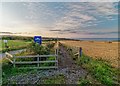
Path to Boyne Bay
This newish path runs down to Boyne Bay parallel with a private road to the quarry
Image: © valenta
Taken: 25 Aug 2018
0.04 miles
2
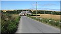
B9139
A road between Portsoy and Banff. It was a very windy day.
Image: © Richard Webb
Taken: 5 Aug 2011
0.06 miles
3
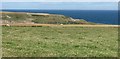
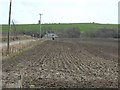
A grass field near Boyne Bay
A view out into the Moray Firth from the coast road past Boyne Bay quarry.
Image: © Richard Webb
Taken: 5 Aug 2011
0.08 miles
5
Scotsmill near Portsoy
Though the cottage looks to be quietly situated it is very close to a quarry and a wind turbine site which is under construction
Image: © Christopher Gillan
Taken: 12 Apr 2006
0.20 miles
6
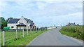
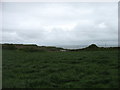
A modern villa near Scotsmill
On a minor road approaching the B9139 from the south. The house on the right is Brangan Cottage on the B9139, between Portsoy and Whitehills.
Image: © Stanley Howe
Taken: 23 Jul 2015
0.25 miles