IMAGES TAKEN NEAR TO
Boyndie, BANFF, AB45 2JQ
Introduction
This page details the photographs taken nearby to AB45 2JQ by members of the Geograph project.
The Geograph project started in 2005 with the aim of publishing, organising and preserving representative images for every square kilometre of Great Britain, Ireland and the Isle of Man.

There are currently over 7.5m images from over14,400 individuals and you can help contribute to the project by visiting https://www.geograph.org.uk
Image Map
Images are licensed for reuse under creativecommons.org/licenses/by-sa/2.0
Notes
- Clicking on the map will re-center to the selected point.
- The higher the marker number, the further away the image location is from the centre of the postcode.
Image Listing (6 Images Found)
Images are licensed for reuse under creativecommons.org/licenses/by-sa/2.0
Image
Details
Distance
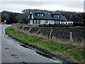
1
Easter Auds
This new house is either an extension or a replacement of an older building.
Image: © Anne Burgess
Taken: 24 Feb 2011
0.10 miles
2
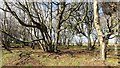
Woodland near Whitehills
A small roadside wood.
Image: © Richard Webb
Taken: 15 Apr 2015
0.11 miles
3
New House near Whitehills.
Recently constructed house just South of Whitehills.
Image: © Christopher Gillan
Taken: 12 Apr 2006
0.14 miles
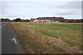
4
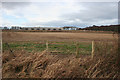
Near Auds
Looking across a field towards a large agricultural building, exact purpose unknown.
Image: © Anne Burgess
Taken: 24 Feb 2011
0.15 miles
5
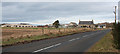
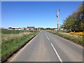
Auds
The traditional house on the left of the BB9121 is Auds.
Image: © Anne Burgess
Taken: 24 Feb 2011
0.15 miles