IMAGES TAKEN NEAR TO
BANFF, AB45 2HN
Introduction
This page details the photographs taken nearby to AB45 2HN by members of the Geograph project.
The Geograph project started in 2005 with the aim of publishing, organising and preserving representative images for every square kilometre of Great Britain, Ireland and the Isle of Man.

There are currently over 7.5m images from over14,400 individuals and you can help contribute to the project by visiting https://www.geograph.org.uk
Image Map
Images are licensed for reuse under creativecommons.org/licenses/by-sa/2.0
Notes
- Clicking on the map will re-center to the selected point.
- The higher the marker number, the further away the image location is from the centre of the postcode.
Image Listing (8 Images Found)
Images are licensed for reuse under creativecommons.org/licenses/by-sa/2.0
Image
Details
Distance
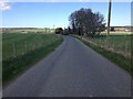
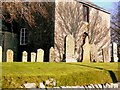
2
Ordiequhill Church
The church is situated near Gordonstown.
Image: © Christopher Gillan
Taken: 7 Nov 2006
0.11 miles
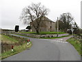
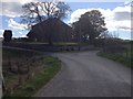
3
Ordiquhill Kirk
The church and churchyard of Ordiquhill.
Image: © Andrew Wood
Taken: 26 Jul 2020
0.12 miles
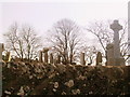
6
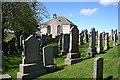
Ordiquhill Kirkyard
The kirkyard is still in use. The kirk is of an unusual design - rectangular, with neither spire nor tower.
Image: © Anne Burgess
Taken: 14 May 2007
0.13 miles
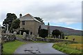
7
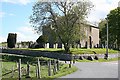
Ordiquhill Kirk
The kirk, disused and beginning to deteriorate, is in contrast to the neatness of the kirkyard.
Image: © Anne Burgess
Taken: 14 May 2007
0.14 miles