IMAGES TAKEN NEAR TO
Cornhill, BANFF, AB45 2HA
Introduction
This page details the photographs taken nearby to AB45 2HA by members of the Geograph project.
The Geograph project started in 2005 with the aim of publishing, organising and preserving representative images for every square kilometre of Great Britain, Ireland and the Isle of Man.

There are currently over 7.5m images from over14,400 individuals and you can help contribute to the project by visiting https://www.geograph.org.uk
Image Map
Images are licensed for reuse under creativecommons.org/licenses/by-sa/2.0
Notes
- Clicking on the map will re-center to the selected point.
- The higher the marker number, the further away the image location is from the centre of the postcode.
Image Listing (7 Images Found)
Images are licensed for reuse under creativecommons.org/licenses/by-sa/2.0
Image
Details
Distance
1
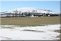
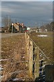
Inchbruich
This farm is just outside Gordonstown. Knock Hill is in the distance.
Image: © Anne Burgess
Taken: 23 Feb 2010
0.03 miles
2
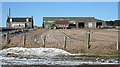
Inchford
The tractor is busy mucking out the byres at Inchford.
Image: © Anne Burgess
Taken: 23 Feb 2010
0.15 miles
3
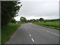
The A95 in Gordonstown, heading for Banff
The B9022 for Portsoy goes off to the left.
Image: © David Purchase
Taken: 11 Jun 2019
0.19 miles
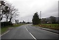
4
Gordonstown
A hamlet on the A95 road to Banff.
Image: © Christopher Gillan
Taken: 7 Nov 2006
0.19 miles
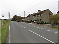
5
Gordonstown
Gordonstown stands at the junction where the B9022 to Portsoy leaves the A95. The signpost at the junction is in this view, lit by afternoon sunshine.
Image: © Anne Burgess
Taken: 22 Feb 2010
0.19 miles
7
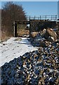
Former Railway Bridge at Inchford
The bridge once carried the B9022 over the Keith to Banff railway line. The rail bed has been ploughed up but the line is marked by the trees beyond the bridge.
Image: © Anne Burgess
Taken: 23 Feb 2010
0.24 miles