IMAGES TAKEN NEAR TO
Boyndie, BANFF, AB45 2DS
Introduction
This page details the photographs taken nearby to AB45 2DS by members of the Geograph project.
The Geograph project started in 2005 with the aim of publishing, organising and preserving representative images for every square kilometre of Great Britain, Ireland and the Isle of Man.

There are currently over 7.5m images from over14,400 individuals and you can help contribute to the project by visiting https://www.geograph.org.uk
Image Map
Images are licensed for reuse under creativecommons.org/licenses/by-sa/2.0
Notes
- Clicking on the map will re-center to the selected point.
- The higher the marker number, the further away the image location is from the centre of the postcode.
Image Listing (2 Images Found)
Images are licensed for reuse under creativecommons.org/licenses/by-sa/2.0
Image
Details
Distance
1
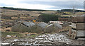
Site of former Banff Distillery
According to the Victorian six-inch map, the Banff Distillery stood here, not where the nearest buildings are, but on the other side of the Burn of Boyndie, where the piles of rubble now lie. It was one of many distilleries built soon after the law on distilling was revised in 1823, and was rebuilt on a new site in 1863, and then again on a more modern plan after being burned down in 1877. It was conveniently sited next to the Great North of Scotland Railway, and had its own siding, the Boyndie Siding. Its three pot stills, one wash still and two low wines stills produced almost 200,000 gallons of Highland malt annually. The whole area looks overripe for redevelopment.
Image: © Anne Burgess
Taken: 24 Feb 2011
0.22 miles
2
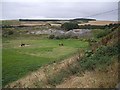
Derelict industrial estate buildings at Inverboyndie
With a horse paddock in the foreground. Viewed from the Old Kirkyard.
Image: © Stanley Howe
Taken: 10 Sep 2012
0.23 miles