IMAGES TAKEN NEAR TO
Cornhill, BANFF, AB45 2DD
Introduction
This page details the photographs taken nearby to AB45 2DD by members of the Geograph project.
The Geograph project started in 2005 with the aim of publishing, organising and preserving representative images for every square kilometre of Great Britain, Ireland and the Isle of Man.

There are currently over 7.5m images from over14,400 individuals and you can help contribute to the project by visiting https://www.geograph.org.uk
Image Map
Images are licensed for reuse under creativecommons.org/licenses/by-sa/2.0
Notes
- Clicking on the map will re-center to the selected point.
- The higher the marker number, the further away the image location is from the centre of the postcode.
Image Listing (2 Images Found)
Images are licensed for reuse under creativecommons.org/licenses/by-sa/2.0
Image
Details
Distance
1
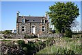
Limestones
This farm house stood empty for twenty years before being bought four years ago and carefully restored by the new owners.
Image: © Anne Burgess
Taken: 30 Apr 2007
0.02 miles
2
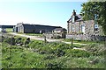
Limestones
Looking across the burn to the steading beyond the house.
Image: © Anne Burgess
Taken: 30 Apr 2007
0.06 miles