IMAGES TAKEN NEAR TO
Cornhill, BANFF, AB45 2BT
Introduction
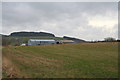
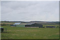
This page details the photographs taken nearby to AB45 2BT by members of the Geograph project.
The Geograph project started in 2005 with the aim of publishing, organising and preserving representative images for every square kilometre of Great Britain, Ireland and the Isle of Man.

There are currently over 7.5m images from over14,400 individuals and you can help contribute to the project by visiting https://www.geograph.org.uk
Image Map
Images are licensed for reuse under creativecommons.org/licenses/by-sa/2.0
Notes
- Clicking on the map will re-center to the selected point.
- The higher the marker number, the further away the image location is from the centre of the postcode.
Image Listing (4 Images Found)
Images are licensed for reuse under creativecommons.org/licenses/by-sa/2.0
Image
Details
Distance
2
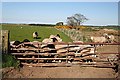
Inquisitive Sheep
I've some across cattle rushing to a gate to see what I am doing, but it's something new to find sheep rushing towards me. I had just pulled up to have a look at the map and they probably thought I was the vehicle bringing their next food.
Image: © Anne Burgess
Taken: 30 Apr 2007
0.15 miles
4
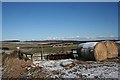
Looking North from Drums of Park
The gentle dip in the middle distance contains the headwater of the Burn of Boyne.
Image: © Anne Burgess
Taken: 23 Feb 2010
0.25 miles