1
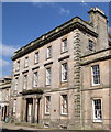
Former Fife Arms, Low Street, Banff
The central block; for more, see: http://portal.historicenvironment.scot/designation/LB22056 .
Image: © Bill Harrison
Taken: 14 Apr 2018
0.01 miles
2
Former Fife Arms, Low Street, Banff
The whole ensemble dating from ca. 1843 of centre block and flanking ranges is A-listed (LB22056): http://portal.historicenvironment.scot/designation/LB22056 .
Image: © Bill Harrison
Taken: 14 Apr 2018
0.01 miles
3
Aul' Fife Arms Pend
The advertisement on the arch of the pend announces the function of the inn as a coaching inn.
Image: © Anne Burgess
Taken: 8 Apr 2014
0.01 miles
4
Aul' Fife Arms Pend
The arched pend is the access to the courtyard where stables and mews catered for the needs of travellers relying on the horse as a means of transport.
Image: © Anne Burgess
Taken: 8 Apr 2014
0.01 miles
5
Low Street, Banff
Image: © Roger Cornfoot
Taken: 1 Jun 2015
0.01 miles
6
Airlie Gardens, Banff
Sheltered housing.
Image: © Bill Harrison
Taken: 14 Apr 2018
0.02 miles
7
Low Street
This façade caught my eye because of the crazy paving effect of the masonry, with the natural markings of the stones horizontal, vertical and diagonal. Pity the building is getting a bit shabby.
Image: © Anne Burgess
Taken: 8 Apr 2014
0.02 miles
8
North range of former Fife Arms, Banff
The central pend (archway to real courtyard) still has 'stabling and horses for hirer' written over it! The bookmakers does nothing whatsoever for the ambience of this listed building.
Image: © Bill Harrison
Taken: 14 Apr 2018
0.02 miles
9
Sheriff Court House
The Sheriff Court and County Hall was designed by James Matthews and built in 1870-1871. It is on the site of the house where George Gordon, Lord Byron, used to visit his grandmother Lady Gight.
Image: © Anne Burgess
Taken: 25 Jul 2014
0.03 miles
10
Banff Parish Kirk
The parish kirk of Banff, dedicated to St Mary, replaced an earlier kirk on High Shore. The original kirk was designed and built in 1790 by Banff architect Andrew Wilson. William Robertson of Elgin added the spire in 1829. Other work was done by Thomas Mackenzie and George Bennet Mitchell. It is a category 'B' listed building. See http://hsewsf.sedsh.gov.uk/hslive/hsstart?P_HBNUM=22029 for more details.
The small temple-like building to the right is Collie Lodge, which was originally a gate lodge to Duff House, facing Collie Street which was where the car park now is. The lodge was almost certainly designed by William Robertson of Elgin, who also designed the nearby Banff Academy. Built in 1836, it now houses the tourist information centre. It is a Category B listed building.
As a complete contrast, in the car park to the left of the kirk is a red-and-white van which, parked permanently there, advertises the Eastside Shopping Centre, better known as the 'Spotty Bag Shop' because of the plastic bags with red and black spots which it supplies to customers to carry away their purchases.
Image: © Anne Burgess
Taken: 19 Mar 2010
0.04 miles


