IMAGES TAKEN NEAR TO
Newtown Drive, MACDUFF, AB44 1SR
Introduction
This page details the photographs taken nearby to Newtown Drive, AB44 1SR by members of the Geograph project.
The Geograph project started in 2005 with the aim of publishing, organising and preserving representative images for every square kilometre of Great Britain, Ireland and the Isle of Man.

There are currently over 7.5m images from over14,400 individuals and you can help contribute to the project by visiting https://www.geograph.org.uk
Image Map
Images are licensed for reuse under creativecommons.org/licenses/by-sa/2.0
Notes
- Clicking on the map will re-center to the selected point.
- The higher the marker number, the further away the image location is from the centre of the postcode.
Image Listing (9 Images Found)
Images are licensed for reuse under creativecommons.org/licenses/by-sa/2.0
Image
Details
Distance
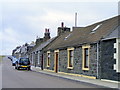
1
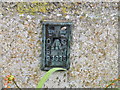
Ordnance Survey Flush Bracket G3995
This can be found on the wall of a house in Buchan Street.
For more detail see : http://www.bench-marks.org.uk/bm17673
Image: © Peter Wood
Taken: 6 Oct 2012
0.05 miles
4
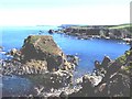
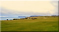
Tarlair
Rugged coastline extends east from Banff. In the distance is Troup Head
Image: © Anne Burgess
Taken: Unknown
0.15 miles
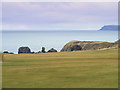
7
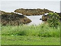
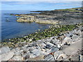
Macduff - Rocky Coast
View from High Shore between the aquarium and Tarlair.
Image: © Colin Smith
Taken: 3 Jul 2024
0.24 miles