IMAGES TAKEN NEAR TO
Souter Street, MACDUFF, AB44 1PB
Introduction
This page details the photographs taken nearby to Souter Street, AB44 1PB by members of the Geograph project.
The Geograph project started in 2005 with the aim of publishing, organising and preserving representative images for every square kilometre of Great Britain, Ireland and the Isle of Man.

There are currently over 7.5m images from over14,400 individuals and you can help contribute to the project by visiting https://www.geograph.org.uk
Image Map
Images are licensed for reuse under creativecommons.org/licenses/by-sa/2.0
Notes
- Clicking on the map will re-center to the selected point.
- The higher the marker number, the further away the image location is from the centre of the postcode.
Image Listing (3 Images Found)
Images are licensed for reuse under creativecommons.org/licenses/by-sa/2.0
Image
Details
Distance
1
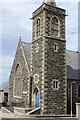
Macduff Arts Centre
Built 1899 as the Free Church, it later became known as Gardner Parish Church of Scotland. Architect A Marshall Mackenzie 1899.
Image: © Leslie Barrie
Taken: 19 Jun 2013
0.17 miles
2
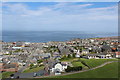
Macduff
View over the town from the top of the War Memorial
Image: © Leslie Barrie
Taken: 19 Jun 2013
0.22 miles
3
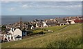
Macduff from the War Memorial
From here the steepness of most of Macduff's streets can be appreciated. The spire is a former kirk now in use as Macduff Arts Centre.
Image: © Anne Burgess
Taken: 26 Jun 2008
0.24 miles