IMAGES TAKEN NEAR TO
Birnie Place, FRASERBURGH, AB43 9WD
Introduction
This page details the photographs taken nearby to Birnie Place, AB43 9WD by members of the Geograph project.
The Geograph project started in 2005 with the aim of publishing, organising and preserving representative images for every square kilometre of Great Britain, Ireland and the Isle of Man.

There are currently over 7.5m images from over14,400 individuals and you can help contribute to the project by visiting https://www.geograph.org.uk
Image Map
Images are licensed for reuse under creativecommons.org/licenses/by-sa/2.0
Notes
- Clicking on the map will re-center to the selected point.
- The higher the marker number, the further away the image location is from the centre of the postcode.
Image Listing (2 Images Found)
Images are licensed for reuse under creativecommons.org/licenses/by-sa/2.0
Image
Details
Distance
1
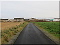
Minor road about to join Boothby Road at the outskirts of Fraserburgh
Looking eastward. The land on the right looked as though it was being prepared for housing development.
Image: © Peter Wood
Taken: 19 Nov 2019
0.13 miles
2
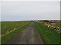
Minor road near to Merryhillock
Looking north-eastwards towards the suburbs of Fraserburgh.
Image: © Peter Wood
Taken: 19 Nov 2019
0.25 miles