IMAGES TAKEN NEAR TO
Charlotte Street, FRASERBURGH, AB43 9TP
Introduction
This page details the photographs taken nearby to Charlotte Street, AB43 9TP by members of the Geograph project.
The Geograph project started in 2005 with the aim of publishing, organising and preserving representative images for every square kilometre of Great Britain, Ireland and the Isle of Man.

There are currently over 7.5m images from over14,400 individuals and you can help contribute to the project by visiting https://www.geograph.org.uk
Image Map
Images are licensed for reuse under creativecommons.org/licenses/by-sa/2.0
Notes
- Clicking on the map will re-center to the selected point.
- The higher the marker number, the further away the image location is from the centre of the postcode.
Image Listing (16 Images Found)
Images are licensed for reuse under creativecommons.org/licenses/by-sa/2.0
Image
Details
Distance
2
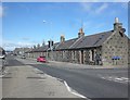
View along Charlotte Street, Fraserburgh
Fraserburgh has wide streets and an attractive 'spacious' and open feeling to it.
Image: © Bill Harrison
Taken: 6 May 2018
0.15 miles
3
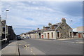
George Street
A broad street in the planned village of Broadsea, George Street was laid out in 1893. Until 1872 Broadsea was not part of Fraserburgh, and while Fraserburgh was mainly a trading port, the fishing fleet operated out of Broadsea until the 1830s.
Image: © Anne Burgess
Taken: 30 Aug 2016
0.16 miles
5
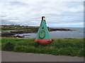
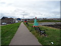
Buoy beside coastal path, Broadsea Shore, Fraserburgh
Image: © JThomas
Taken: 22 Aug 2020
0.17 miles
8
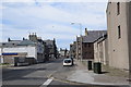
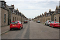
Main road through town
The A90 is quiet on a Sunday afternoon. This important trunk road, which runs from Edinburgh to Fraserburgh (see: https://en.wikipedia.org/wiki/A90_road ), ends at the junction with the A98 in the distance.
Image: © Bill Harrison
Taken: 6 May 2018
0.21 miles
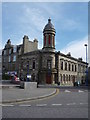
9
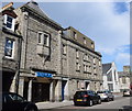
Bingo!
Bingo hall on Mid Street. The 1925 OS 25-inch map shows the building to be a cinema. In the right background is the almost new Fraserburgh United Reformed church, erected after the previous church was destroyed in an arson attack in 2000.
Image: © Bill Harrison
Taken: 6 May 2018
0.21 miles
10
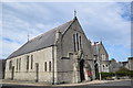
Our Lady Star of the Sea and St Drostan's RC church, Fraserburgh
The church dates from 1895 and lies on an approximate north-south orientation at the junction of Commerce Street and Lodge Walk. Just visible to the right is the presbytery. St Drostan (https://en.wikipedia.org/wiki/Drostan ) was a companion of St Columba and is thought to have been active in Aberdeenshire in the late 6th Century.
Image: © Bill Harrison
Taken: 6 May 2018
0.21 miles