IMAGES TAKEN NEAR TO
Seaforth Street, FRASERBURGH, AB43 9BD
Introduction
This page details the photographs taken nearby to Seaforth Street, AB43 9BD by members of the Geograph project.
The Geograph project started in 2005 with the aim of publishing, organising and preserving representative images for every square kilometre of Great Britain, Ireland and the Isle of Man.

There are currently over 7.5m images from over14,400 individuals and you can help contribute to the project by visiting https://www.geograph.org.uk
Image Map
Images are licensed for reuse under creativecommons.org/licenses/by-sa/2.0
Notes
- Clicking on the map will re-center to the selected point.
- The higher the marker number, the further away the image location is from the centre of the postcode.
Image Listing (122 Images Found)
Images are licensed for reuse under creativecommons.org/licenses/by-sa/2.0
Image
Details
Distance
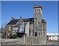
1
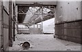
Fraserburgh station
Inside the derelict Fraserburgh Station, which closed to passengers in 1965. The former engine shed can be seen through the gap.
Image: © Richard Sutcliffe
Taken: Unknown
0.02 miles
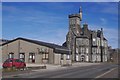
3
Dalrymple Hall
Built in 1881-1883 and named after Captain John Dalrymple, who owned the land including Image] and gave over half the cost of building it. The architects were Jenkins and Marr. It contained a large hall, café, dining room, newsroom, recreation room, library, museum, art school, public baths and the sheriff court. It is now an arts centre.
Image: © Anne Burgess
Taken: 14 Oct 2020
0.02 miles
4
Dalrymple Hall, Fraserburgh
Named after Captain John Dalrymple, who helped to pay for the building, which originally featured a public hall, library, museum, school rooms and sheriff court. Now the local arts centre.
Image: © Bill Harrison
Taken: 6 May 2018
0.02 miles
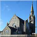
5
View down Victoria Street, Fraserburgh
The south kirk with its spectacular spire towers over the floodlights of Bellslea Park, home of Fraserburgh FC.
Image: © Bill Harrison
Taken: 6 May 2018
0.03 miles
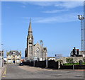
6
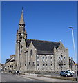
Fraserburgh south kirk
Built as the free kirk in exuberant style in 1878. B-listed (LB31878): http://portal.historicenvironment.scot/designation/LB31878 .
Image: © Bill Harrison
Taken: 6 May 2018
0.04 miles
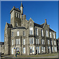
7
South Kirk
This was originally a Free Kirk, built in 1878-1880 to a design by John Bridgeford Pirie (1848-1892), later well known for his personal Gothic style of ecclesiastical architecture.
Image: © Anne Burgess
Taken: 14 Oct 2020
0.04 miles
8
The Warld's End
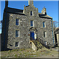
This elegant house at 11 Dalrymple Street caught my eye instantly, though it was difficult to photograph owing to 21st century vehicles parked in front; and the 'For sale/To let' sign does nothing to enhance it. It dates from the 18th century, though no-one seems to know exactly when it was built; some say about 1767. It belonged to 'Old Glenbucket' (John Gordon of Glenbuchat), whose estates were forfeited after the Jacobite Rising of 1746, and it (or possibly its predecessor, if it was built in 1767) was sold by public roup on 2 July 1766 to Charles Gordon, who paid just over £38 for it. It is a Category B Listed Building and is described in 'The Buildings of Scotland' as one of the finest Aberdeenshire houses of its date. In the 1850s the owner of the Warld's End seems to have been one Captain John Dalrymple, and after that until the middle of the 20th century it was owned by the company who ran Image It was apparently restored in 1980, but is again looking tired and neglected.
The blue plaque by the door commemorates Thomas Blake Glover, 'The Scottish Samurai' (1838-1911) https://en.wikipedia.org/wiki/Thomas_Blake_Glover who was born just round the corner at 15 Commerce Street, in a house that was destroyed by a bomb during the Second World War. I read somewhere that Glover may have worked in the Warld's End, but that seems unlikely as his family left Fraserburgh when he was six years old.
Image: © Anne Burgess
Taken: 14 Oct 2020
0.04 miles
9
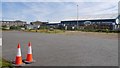
Fraserburgh railway station (site), Aberdeenshire
Opened in 1865 by the Formartine and Buchan Railway, later part of the Great North of Scotland Railway. It was the terminus of the line from Aberdeen via Maud Junction, and closed to passengers in 1965, and completely in 1979.
View north west on South Harbour Street towards the former buffers. The passenger terminus was immediately to the left of where the road now is, the goods yard to the right. The area was an industrial estate when this image was taken.
Image: © Nigel Thompson
Taken: 4 Sep 2019
0.05 miles