IMAGES TAKEN NEAR TO
Braeheads, FRASERBURGH, AB43 8ZP
Introduction
This page details the photographs taken nearby to Braeheads, AB43 8ZP by members of the Geograph project.
The Geograph project started in 2005 with the aim of publishing, organising and preserving representative images for every square kilometre of Great Britain, Ireland and the Isle of Man.

There are currently over 7.5m images from over14,400 individuals and you can help contribute to the project by visiting https://www.geograph.org.uk
Image Map
Images are licensed for reuse under creativecommons.org/licenses/by-sa/2.0
Notes
- Clicking on the map will re-center to the selected point.
- The higher the marker number, the further away the image location is from the centre of the postcode.
Image Listing (35 Images Found)
Images are licensed for reuse under creativecommons.org/licenses/by-sa/2.0
Image
Details
Distance
1
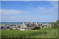
View over the rooftops, St Combs
Former granite fishermen's cottages at St Combs. In the full size photo a ferry from Orkney or Shetland to Aberdeen can be seen passing in the distance.
Image: © Bill Harrison
Taken: 5 Jun 2022
0.04 miles
2
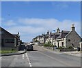
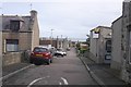
West Street, St Combs
Here, the terraced houses face the street, unlike the more unconventional arrangement on East Street: https://www.geograph.org.uk/photo/7245247 .
Image: © Bill Harrison
Taken: 5 Jun 2022
0.05 miles
7
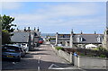
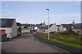
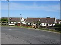
Mid Street, St Combs
The main streets run approximately north-sound with the gable ends of the former fishermen's cottages facing the road.
Image: © Bill Harrison
Taken: 5 Jun 2022
0.10 miles
9
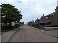
St. Combs railway station (site), Aberdeenshire
Opened in 1903 by the Great North of Scotland Railway as the terminus of the short 'light railway' branch from Fraserburgh, this station closed with the branch line in 1965.
View north from near the buffer stop. The railway line stretched away from this viewpoint, with the station site being behind the house on the right. As can be seen, the site has been completely redeveloped.
Image: © Nigel Thompson
Taken: 4 Sep 2019
0.11 miles
