IMAGES TAKEN NEAR TO
Crimond, FRASERBURGH, AB43 8YH
Introduction
This page details the photographs taken nearby to AB43 8YH by members of the Geograph project.
The Geograph project started in 2005 with the aim of publishing, organising and preserving representative images for every square kilometre of Great Britain, Ireland and the Isle of Man.

There are currently over 7.5m images from over14,400 individuals and you can help contribute to the project by visiting https://www.geograph.org.uk
Image Map
Images are licensed for reuse under creativecommons.org/licenses/by-sa/2.0
Notes
- Clicking on the map will re-center to the selected point.
- The higher the marker number, the further away the image location is from the centre of the postcode.
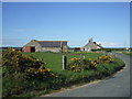
Image Listing (7 Images Found)
Images are licensed for reuse under creativecommons.org/licenses/by-sa/2.0
Image
Details
Distance
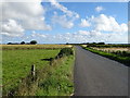
3
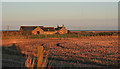
Greengate
It's not looking very green in winter colours and light from the setting sun. Compare with Image], taken almost eight years earlier.
Image: © Anne Burgess
Taken: 6 Jan 2015
0.03 miles
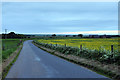
5
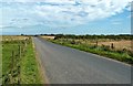
Towards Netherton
This minor road goes to Netherton Farm and then connects with the A90.
Image: © Mary and Angus Hogg
Taken: 23 Aug 2019
0.08 miles