IMAGES TAKEN NEAR TO
Lonmay, FRASERBURGH, AB43 8RL
Introduction
This page details the photographs taken nearby to AB43 8RL by members of the Geograph project.
The Geograph project started in 2005 with the aim of publishing, organising and preserving representative images for every square kilometre of Great Britain, Ireland and the Isle of Man.

There are currently over 7.5m images from over14,400 individuals and you can help contribute to the project by visiting https://www.geograph.org.uk
Image Map
Images are licensed for reuse under creativecommons.org/licenses/by-sa/2.0
Notes
- Clicking on the map will re-center to the selected point.
- The higher the marker number, the further away the image location is from the centre of the postcode.
Image Listing (8 Images Found)
Images are licensed for reuse under creativecommons.org/licenses/by-sa/2.0
Image
Details
Distance
1
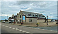
Ban Car Hotel
This hotel has been extended since the last shot was taken - see Image for a 2006 view.
Image: © Mary and Angus Hogg
Taken: 23 Aug 2019
0.01 miles

4
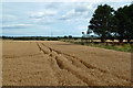
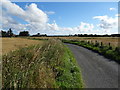
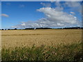
Barley field at Lonmay
Rich Buchan farmland viewed just before harvest.
Image: © Mary and Angus Hogg
Taken: 23 Aug 2019
0.08 miles
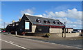
5
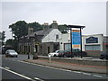
Ban Car Hotel, Lonmay
Small country hotel on Peterhead to Fraserburgh road. Large function area which is popular for local weddings.
Image: © Ken Fitlike
Taken: 16 Sep 2006
0.08 miles
6
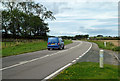
The A90 at Lonmay
The vehicle is going towards Fraserburgh.
Image: © Mary and Angus Hogg
Taken: 23 Aug 2019
0.18 miles