IMAGES TAKEN NEAR TO
Crimond, FRASERBURGH, AB43 8QD
Introduction
This page details the photographs taken nearby to AB43 8QD by members of the Geograph project.
The Geograph project started in 2005 with the aim of publishing, organising and preserving representative images for every square kilometre of Great Britain, Ireland and the Isle of Man.

There are currently over 7.5m images from over14,400 individuals and you can help contribute to the project by visiting https://www.geograph.org.uk
Image Map
Images are licensed for reuse under creativecommons.org/licenses/by-sa/2.0
Notes
- Clicking on the map will re-center to the selected point.
- The higher the marker number, the further away the image location is from the centre of the postcode.
Image Listing (10 Images Found)
Images are licensed for reuse under creativecommons.org/licenses/by-sa/2.0
Image
Details
Distance
1
Upper Ridinghill
If you wish to operate an Equestrian Stud business 'Ridinghill' is a grand name for your base!
http://npsscotland.co.uk/ridinghillstud.htm
Image: © Ken Fitlike
Taken: 10 Apr 2007
0.01 miles
6
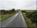
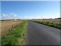
Minor road heading towards North Ballearn
Looking southward.
Image: © Peter Wood
Taken: 22 Nov 2019
0.19 miles
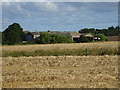
7
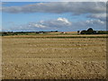
View from Ridinghill ......
....towards Mormond Hill
Image: © Ken Fitlike
Taken: 10 Apr 2007
0.22 miles
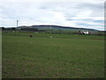
9
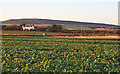
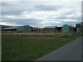
Park of Logie
A traditional 18th century farmhouse, with Mormond Hill in the distance.
Image: © Anne Burgess
Taken: 6 Jan 2015
0.22 miles
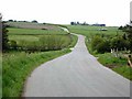
10
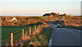
Causeyhill and Upper Ridinghill
Causeyhill is to the left of the road, and Upper Ridinghill, which is an equestrian centre and stud, is on the skyline at right.
Image: © Anne Burgess
Taken: 6 Jan 2015
0.23 miles