IMAGES TAKEN NEAR TO
Rathen, FRASERBURGH, AB43 7UJ
Introduction
This page details the photographs taken nearby to AB43 7UJ by members of the Geograph project.
The Geograph project started in 2005 with the aim of publishing, organising and preserving representative images for every square kilometre of Great Britain, Ireland and the Isle of Man.

There are currently over 7.5m images from over14,400 individuals and you can help contribute to the project by visiting https://www.geograph.org.uk
Image Map
Images are licensed for reuse under creativecommons.org/licenses/by-sa/2.0
Notes
- Clicking on the map will re-center to the selected point.
- The higher the marker number, the further away the image location is from the centre of the postcode.
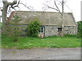
Image Listing (5 Images Found)
Images are licensed for reuse under creativecommons.org/licenses/by-sa/2.0
Image
Details
Distance
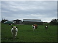
2
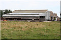
Quarryhead
Big barns and byres at Quarryhead Farm.
Image: © Anne Burgess
Taken: 30 Aug 2016
0.05 miles
4
Winter cereals
A wet arable field inside a right angled road bend.
Image: © Richard Webb
Taken: 21 Dec 2011
0.14 miles
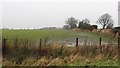
5
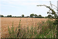
Field near Quarryhead
A field of barely almost ready for cutting. There's a glimpse of Quarryhead beyond it.
Image: © Anne Burgess
Taken: 30 Aug 2016
0.17 miles