IMAGES TAKEN NEAR TO
Cromarty Crescent, FRASERBURGH, AB43 7FZ
Introduction
This page details the photographs taken nearby to Cromarty Crescent, AB43 7FZ by members of the Geograph project.
The Geograph project started in 2005 with the aim of publishing, organising and preserving representative images for every square kilometre of Great Britain, Ireland and the Isle of Man.

There are currently over 7.5m images from over14,400 individuals and you can help contribute to the project by visiting https://www.geograph.org.uk
Image Map
Images are licensed for reuse under creativecommons.org/licenses/by-sa/2.0
Notes
- Clicking on the map will re-center to the selected point.
- The higher the marker number, the further away the image location is from the centre of the postcode.
Image Listing (6 Images Found)
Images are licensed for reuse under creativecommons.org/licenses/by-sa/2.0
Image
Details
Distance
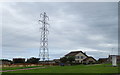
1
View West from Middleburgh Trig Point
Image: © thejackrustles
Taken: 19 Apr 2015
0.05 miles
2
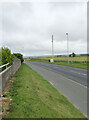
Boothby Road and Strichen Road (A981) roundabout junction, Fraserburgh
Looking westward at Cairn Hill.
Image: © Peter Wood
Taken: 19 Nov 2019
0.06 miles
3
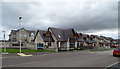
New housing development on the south side of Fraserburgh
Image: © JThomas
Taken: 22 Aug 2020
0.07 miles
5
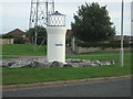
Roundabout feature, Fraserburgh
On the leaving town to Strichen roundabout... a nice echo of the Kinnaird Head Lighthouse.
Image: © Ken Fitlike
Taken: 19 Sep 2006
0.21 miles
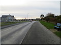
6
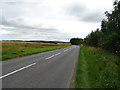
A981 towards Strichen
Heading south west from Fraserburgh.
Image: © JThomas
Taken: 22 Aug 2020
0.24 miles