IMAGES TAKEN NEAR TO
Memsie, FRASERBURGH, AB43 7BR
Introduction
This page details the photographs taken nearby to AB43 7BR by members of the Geograph project.
The Geograph project started in 2005 with the aim of publishing, organising and preserving representative images for every square kilometre of Great Britain, Ireland and the Isle of Man.

There are currently over 7.5m images from over14,400 individuals and you can help contribute to the project by visiting https://www.geograph.org.uk
Image Map
Images are licensed for reuse under creativecommons.org/licenses/by-sa/2.0
Notes
- Clicking on the map will re-center to the selected point.
- The higher the marker number, the further away the image location is from the centre of the postcode.
Image Listing (3 Images Found)
Images are licensed for reuse under creativecommons.org/licenses/by-sa/2.0
Image
Details
Distance
1
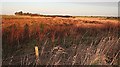
Nethermill
Early sunshine highlights the rushes at Nethermill. In the distance there is a glimpse of Bodychell Farm among the trees.
Image: © Anne Burgess
Taken: 16 Jan 2007
0.10 miles
2
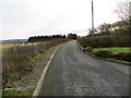
Track leading to Muirton
Looking southward.
Image: © Peter Wood
Taken: 19 Nov 2019
0.12 miles
3
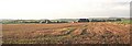
Muirton of Memsie
Looking south from the crossroads towards Nethermill and Muirton near Memsie.
Image: © Anne Burgess
Taken: 26 Oct 2006
0.12 miles