IMAGES TAKEN NEAR TO
Muir Road, FRASERBURGH, AB43 7AQ
Introduction
This page details the photographs taken nearby to Muir Road, AB43 7AQ by members of the Geograph project.
The Geograph project started in 2005 with the aim of publishing, organising and preserving representative images for every square kilometre of Great Britain, Ireland and the Isle of Man.

There are currently over 7.5m images from over14,400 individuals and you can help contribute to the project by visiting https://www.geograph.org.uk
Image Map
Images are licensed for reuse under creativecommons.org/licenses/by-sa/2.0
Notes
- Clicking on the map will re-center to the selected point.
- The higher the marker number, the further away the image location is from the centre of the postcode.
Image Listing (5 Images Found)
Images are licensed for reuse under creativecommons.org/licenses/by-sa/2.0
Image
Details
Distance
1
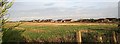
Memsie
Ribbon development of modern bungalows along the road to Rathen.
Image: © Anne Burgess
Taken: 26 Oct 2006
0.15 miles
2
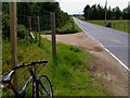
View towards Memsie from the Broch side
Image: © Wayne Easton
Taken: 20 Jun 2012
0.18 miles
3
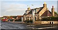
Memsie
A traditional cottage stands at the crossroads, and modern bungalows line the road beyond.
Image: © Anne Burgess
Taken: 26 Oct 2006
0.20 miles
4
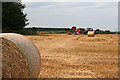
Baling at Memsie
The red machine was collecting straw in this field at Cairns of Memsie and rolling it into bales.
Image: © Anne Burgess
Taken: 30 Aug 2016
0.20 miles
5
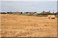
Memsie
Most of Memsie consists of a single street, with houses on one side only and fields on the other.
Image: © Anne Burgess
Taken: 30 Aug 2016
0.20 miles