IMAGES TAKEN NEAR TO
Memsie, FRASERBURGH, AB43 7AP
Introduction
This page details the photographs taken nearby to AB43 7AP by members of the Geograph project.
The Geograph project started in 2005 with the aim of publishing, organising and preserving representative images for every square kilometre of Great Britain, Ireland and the Isle of Man.

There are currently over 7.5m images from over14,400 individuals and you can help contribute to the project by visiting https://www.geograph.org.uk
Image Map
Images are licensed for reuse under creativecommons.org/licenses/by-sa/2.0
Notes
- Clicking on the map will re-center to the selected point.
- The higher the marker number, the further away the image location is from the centre of the postcode.
Image Listing (2 Images Found)
Images are licensed for reuse under creativecommons.org/licenses/by-sa/2.0
Image
Details
Distance
1
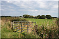
Overtown of Memsie
The modern maps name this farm simply as Overtown, but the first edition of the Ordnance Survey six-inch map says Overtown of Memsie.
Image: © Anne Burgess
Taken: 30 Aug 2016
0.08 miles
2
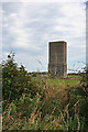
No Chimney without Fire?
Of course it might not be a chimney at all, but it has that look of a World War 2 military structure, and I speculate that it was a chimney at the end of a wood block that has since vanished.
Image: © Anne Burgess
Taken: 30 Aug 2016
0.12 miles