IMAGES TAKEN NEAR TO
Burnshangie Road, FRASERBURGH, AB43 6TX
Introduction
This page details the photographs taken nearby to Burnshangie Road, AB43 6TX by members of the Geograph project.
The Geograph project started in 2005 with the aim of publishing, organising and preserving representative images for every square kilometre of Great Britain, Ireland and the Isle of Man.

There are currently over 7.5m images from over14,400 individuals and you can help contribute to the project by visiting https://www.geograph.org.uk
Image Map
Images are licensed for reuse under creativecommons.org/licenses/by-sa/2.0
Notes
- Clicking on the map will re-center to the selected point.
- The higher the marker number, the further away the image location is from the centre of the postcode.
Image Listing (18 Images Found)
Images are licensed for reuse under creativecommons.org/licenses/by-sa/2.0
Image
Details
Distance
1
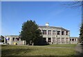
Strichen primary school
Built ca. 1936 in what the Buildings of Scotland guide calls "stripped classicism". School roll (2020): 116 (estimated).
Image: © Bill Harrison
Taken: 16 Apr 2021
0.12 miles
3
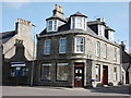
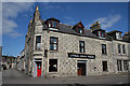
Strichen pharmacy
A vital resource for the village on a prominent corner site at the junction of the High Street and Bridge Street.
Image: © Bill Harrison
Taken: 19 Apr 2016
0.19 miles
4
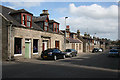
High Street
A classic example of a planned town, the houses built with their long elevations on wide streets.
Image: © Anne Burgess
Taken: 7 May 2015
0.20 miles
5
White Horse Hotel
The hotel stands on the High Street, and offers all the usual services. Notice the stonework, which features large pale granite blocks interspersed with stacks of small dark blocks. This style of masonry is termed cherry-cocking, and is traditional in Buchan.
Image: © Anne Burgess
Taken: 7 May 2015
0.20 miles
6
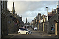
High Street
The view up the High Street of the planned town of Strichen leads the eye to the Gothic style Parish Kirk, originally the Free Kirk, and built in 1893-1894 to a design by Duncan McMillan (1840-1928). The white car has just turned right out of the lane on the left.
Image: © Anne Burgess
Taken: 14 Oct 2020
0.20 miles
7
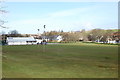
Lest We Forget - Strichen
The Strichen memorial out side the town hall.
Image: © Ralph Greig
Taken: 28 Dec 2021
0.21 miles
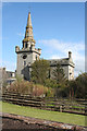
8
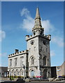
Town House, Strichen
The most impressive building in Strichen is surely the A-listed (http://www.britishlistedbuildings.co.uk/sc-16551-town-house-high-street-and-bridge-street-#.VxuVZ6T2amQ ) town house, designed by John Smith ca. 1816 in the style of a medieval tolbooth (combined council chamber, courthouse and jail): https://en.wikipedia.org/wiki/Tolbooth .
Image: © Bill Harrison
Taken: 19 Apr 2016
0.21 miles
9
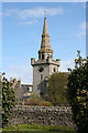
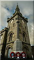
Tower with Steeple
The tower and steeple of the Town House make up the most prominent feature of Strichen town centre. It was built in the early 19th century, and possibly designed by John Smith (1781-1852).
Image: © Anne Burgess
Taken: 7 May 2015
0.21 miles
10
Town House
The Town house stands on the corner of Bridge Street and High Street, and dominates the centre of the town. This is the back of the building from one of the many lanes that link Water Street and High Street. The building was possibly designed by John Smith (1781-1852) and it is partly inspired by 16th century Scottish tolbooths.
Image: © Anne Burgess
Taken: 7 May 2015
0.21 miles