IMAGES TAKEN NEAR TO
New Pitsligo, FRASERBURGH, AB43 6PR
Introduction
This page details the photographs taken nearby to AB43 6PR by members of the Geograph project.
The Geograph project started in 2005 with the aim of publishing, organising and preserving representative images for every square kilometre of Great Britain, Ireland and the Isle of Man.

There are currently over 7.5m images from over14,400 individuals and you can help contribute to the project by visiting https://www.geograph.org.uk
Image Map
Images are licensed for reuse under creativecommons.org/licenses/by-sa/2.0
Notes
- Clicking on the map will re-center to the selected point.
- The higher the marker number, the further away the image location is from the centre of the postcode.
Image Listing (5 Images Found)
Images are licensed for reuse under creativecommons.org/licenses/by-sa/2.0
Image
Details
Distance
1
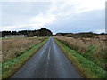
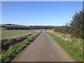
Minor road approaching Liberty Farm
Looking northward.
Image: © Peter Wood
Taken: 21 Nov 2019
0.11 miles
4
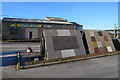
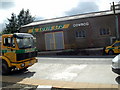
Lovie Limited
This company makes concrete and quarry products. In the office car park are displays of samples of their products.
Image: © Anne Burgess
Taken: 20 Jan 2017
0.18 miles