IMAGES TAKEN NEAR TO
Church Crescent, FRASERBURGH, AB43 6LP
Introduction
This page details the photographs taken nearby to Church Crescent, AB43 6LP by members of the Geograph project.
The Geograph project started in 2005 with the aim of publishing, organising and preserving representative images for every square kilometre of Great Britain, Ireland and the Isle of Man.

There are currently over 7.5m images from over14,400 individuals and you can help contribute to the project by visiting https://www.geograph.org.uk
Image Map
Images are licensed for reuse under creativecommons.org/licenses/by-sa/2.0
Notes
- Clicking on the map will re-center to the selected point.
- The higher the marker number, the further away the image location is from the centre of the postcode.
Image Listing (24 Images Found)
Images are licensed for reuse under creativecommons.org/licenses/by-sa/2.0
Image
Details
Distance
1
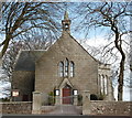
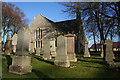
New Pitsligo parish kirk
The kirk, on the hillside above the village, was built in a north-south orientation with the west transept and east organ gallery added later.
Image: © Bill Harrison
Taken: 19 Apr 2016
0.06 miles
2
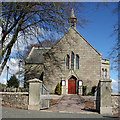
New Pitsligo Parish Kirk
The kirk dates from 1850 and was designed by John Henderson. It was originally a 'quoad sacra' kirk; that is, a kirk built to serve a place which had a significant population but was some distance from the parish kirk, which in this case was Tyrie Parish Kirk, about 6 miles distant.
Image: © Anne Burgess
Taken: 7 May 2015
0.06 miles
3
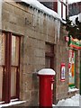
Icicles
Wintry scene in New Pitsligo during the snowfall in January 2010
Image: © JBPM67
Taken: 10 Jan 2010
0.06 miles
4
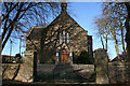
South facing entrance to Church at New Pitsligo.
Image: © Des Colhoun
Taken: 14 Jan 2007
0.06 miles
5
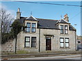
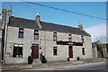
New Pitsligo villa
A step-up from the terraced weavers' cottages...
Image: © Bill Harrison
Taken: 19 Apr 2016
0.08 miles
6
The west wall of Church of Scotland, New Pitsligo.
Image: © Des Colhoun
Taken: 14 Jan 2007
0.10 miles
7
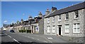
High Street
New Pitsligo is one of the planned villages of the Scottish Enlightenment. It was founded by Sir William Forbes of Monymusk in 1787. Paradoxically, it was built in the parish of Tyrie rather than in the parish of Pitsligo, which lies further north, on the coast. Where the village now stands was a farm named Cyaak, and this name is still used locally.
Image: © Anne Burgess
Taken: 7 May 2009
0.10 miles
8
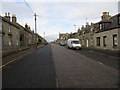
High Street (A950), New Pitsligo
Looking north-westward.
Image: © Peter Wood
Taken: 21 Nov 2019
0.10 miles
9
The Pitsligo Arms, New Pitsligo
B-listed coaching inn from ca. 1790: http://www.britishlistedbuildings.co.uk/sc-16453-pitsligo-arms-hotel-high-street-tyrie#.VxtOxaT2amQ . The gate-piers to the rear courtyard have their own listing: http://www.britishlistedbuildings.co.uk/sc-16454-pitsligo-arms-hotel-gatepiers-to-rear-cou#.VxtOfaT2amQ .
Image: © Bill Harrison
Taken: 19 Apr 2016
0.11 miles
10
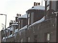
Cold weather icicles
Icicles formed around house in New Pitsligo
Image: © JBPM67
Taken: 10 Jan 2010
0.12 miles