IMAGES TAKEN NEAR TO
Pennan, FRASERBURGH, AB43 6JD
Introduction
This page details the photographs taken nearby to AB43 6JD by members of the Geograph project.
The Geograph project started in 2005 with the aim of publishing, organising and preserving representative images for every square kilometre of Great Britain, Ireland and the Isle of Man.

There are currently over 7.5m images from over14,400 individuals and you can help contribute to the project by visiting https://www.geograph.org.uk
Image Map
Images are licensed for reuse under creativecommons.org/licenses/by-sa/2.0
Notes
- Clicking on the map will re-center to the selected point.
- The higher the marker number, the further away the image location is from the centre of the postcode.
Image Listing (5 Images Found)
Images are licensed for reuse under creativecommons.org/licenses/by-sa/2.0
Image
Details
Distance
1
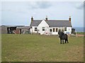
Cottage above Pennan
Complete with Shetland pony.
Image: © Oliver Dixon
Taken: 21 May 2008
0.02 miles
2
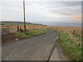
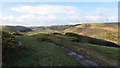
Minor road at Glenquithle descending towards Pennan Bay
Looking northward.
Image: © Peter Wood
Taken: 20 Nov 2019
0.06 miles
3
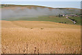
Barley at Glenquithie
The farm on the other side of the den is Mains of Auchmedden. Notice the finger of haar dissipating as it creeps up the den from the sea.
Image: © Anne Burgess
Taken: 25 Jul 2014
0.17 miles
4
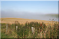
Barley and Haar
The haar is coming up from the sea, and dissipating as soon as it is away from the shore, so the barley is in sunshine.
Image: © Anne Burgess
Taken: 25 Jul 2014
0.18 miles
5
Road to Chapelden
Looking up the inviting and seemingly deserted glen of the Tore Burn.
Image: © Richard Webb
Taken: 15 Apr 2015
0.22 miles