IMAGES TAKEN NEAR TO
New Aberdour, FRASERBURGH, AB43 6HP
Introduction
This page details the photographs taken nearby to AB43 6HP by members of the Geograph project.
The Geograph project started in 2005 with the aim of publishing, organising and preserving representative images for every square kilometre of Great Britain, Ireland and the Isle of Man.

There are currently over 7.5m images from over14,400 individuals and you can help contribute to the project by visiting https://www.geograph.org.uk
Image Map
Images are licensed for reuse under creativecommons.org/licenses/by-sa/2.0
Notes
- Clicking on the map will re-center to the selected point.
- The higher the marker number, the further away the image location is from the centre of the postcode.
Image Listing (6 Images Found)
Images are licensed for reuse under creativecommons.org/licenses/by-sa/2.0
Image
Details
Distance
1
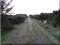
Hedge-lined track leading to Bridestonefold
Looking south-eastward.
Image: © Peter Wood
Taken: 19 Nov 2019
0.07 miles
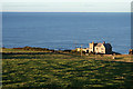
2
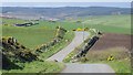
Winding road
The coast road passes Dundarg Castle.
Image: © Richard Webb
Taken: 15 Apr 2015
0.14 miles
3
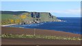
View towards Strahangles Point
Arable foreground and a wild coast between Rosehearty and Pennan.
Image: © Richard Webb
Taken: 15 Apr 2015
0.23 miles
4
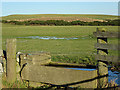
Cattle Trough
A concrete trough, still apparently in use, built into a dyke between two fields.
Image: © Anne Burgess
Taken: 20 Jan 2017
0.24 miles
6
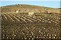
Sheep and Neeps
A flock of sheep has been put into a park of neeps, which provide an easy source of winter fodder when the grass is not growing.
Image: © Anne Burgess
Taken: 20 Jan 2017
0.24 miles