IMAGES TAKEN NEAR TO
Old Deer, PETERHEAD, AB42 5JT
Introduction
This page details the photographs taken nearby to AB42 5JT by members of the Geograph project.
The Geograph project started in 2005 with the aim of publishing, organising and preserving representative images for every square kilometre of Great Britain, Ireland and the Isle of Man.

There are currently over 7.5m images from over14,400 individuals and you can help contribute to the project by visiting https://www.geograph.org.uk
Image Map
Images are licensed for reuse under creativecommons.org/licenses/by-sa/2.0
Notes
- Clicking on the map will re-center to the selected point.
- The higher the marker number, the further away the image location is from the centre of the postcode.
Image Listing (39 Images Found)
Images are licensed for reuse under creativecommons.org/licenses/by-sa/2.0
Image
Details
Distance
1
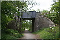
Deer Bridge
A roadbridge, carrying the B9030 to Old Deer, over the Buchan Line Walkway near Aden.
Image: © Andrew Wood
Taken: 5 Jun 2011
0.13 miles
2
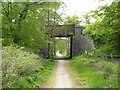
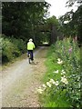
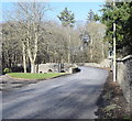
Formartine and Buchan Way at Old Deer
Old railways in northern Aberdeenshire have been developed as walkways and linear nature reserves under the title "Formartine and Buchan Way". The length of the trail from Dyce to Peterhead is 60 Km long with a spur from Maud to Fraserburgh. It is also publicised as a cycleway. Here it passes under the B9029.
Image: © Oliver Dixon
Taken: 22 May 2008
0.13 miles
3
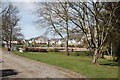
Playground and new builds, Old Deer
Too new for the OS map as of April 2016.
Image: © Bill Harrison
Taken: 2 Apr 2016
0.14 miles
4
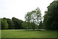
Aden Parkland
Open parkland and woodland at the edge of Aden Country Park.
Image: © Andrew Wood
Taken: 5 Jun 2011
0.15 miles
5
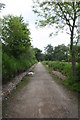
Formartine and Buchan Way -Another Bridge
Meadowsweet, willowherb and Kirsty.
Image: © Mike and Kirsty Grundy
Taken: 26 Jul 2007
0.16 miles
6
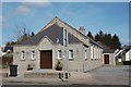
Old Deer public hall
A substantial granite building for a small village. The dedication stone notes that it was the gift in 1937 of the Reverend Robert Kemp, who served as minister to the village for 54 years: http://www.olddeer.org.uk/cgi-bin/delivtext?currentpageno=4&textsection=Geography%20and%20history
Image: © Bill Harrison
Taken: 2 Apr 2016
0.17 miles
7
Formartine and Buchan Line
The long redundant Buchan Line railbed converted into a walkway.
Image: © Andrew Wood
Taken: 5 Jun 2011
0.17 miles
8
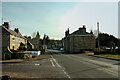
Old Deer
Looking towards the churches and the centre of the village
Image: © Ralph Greig
Taken: 9 Feb 2023
0.18 miles
9
Bridge of Deer...
...over South Ugie Water carrying the B9030, which meets the A950 a few hundred metres to the north. Built ca. 1800 and B-listed (LB16087): http://portal.historicenvironment.scot/designation/LB16087 .
Image: © Bill Harrison
Taken: 22 Feb 2020
0.18 miles
10
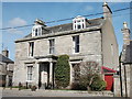
Old Bank House, Old Deer
As the name implies, the former Clydesdale Bank and before that, the North of Scotland Bank. B-listed: http://www.britishlistedbuildings.co.uk/sc-16084-clydesdale-bank-abbey-street-old-deer#.VwbHfaT2amQ .
Image: © Bill Harrison
Taken: 2 Apr 2016
0.19 miles