IMAGES TAKEN NEAR TO
Bain Gardens, PETERHEAD, AB42 5HA
Introduction
This page details the photographs taken nearby to Bain Gardens, AB42 5HA by members of the Geograph project.
The Geograph project started in 2005 with the aim of publishing, organising and preserving representative images for every square kilometre of Great Britain, Ireland and the Isle of Man.

There are currently over 7.5m images from over14,400 individuals and you can help contribute to the project by visiting https://www.geograph.org.uk
Image Map
Images are licensed for reuse under creativecommons.org/licenses/by-sa/2.0
Notes
- Clicking on the map will re-center to the selected point.
- The higher the marker number, the further away the image location is from the centre of the postcode.
Image Listing (9 Images Found)
Images are licensed for reuse under creativecommons.org/licenses/by-sa/2.0
Image
Details
Distance
2
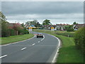
South Street, (A952), Mintlaw
Towards Ellon.
Image: © JThomas
Taken: 22 Aug 2020
0.08 miles
5
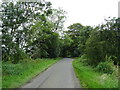
Nether Aden Road, Mintlaw
Towards Old Dear.
Image: © JThomas
Taken: 22 Aug 2020
0.21 miles
6
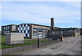
Mintlaw primary school
School roll (2017-18): 46 nursery and 171 primary pupils.
Image: © Bill Harrison
Taken: 6 May 2018
0.23 miles
7
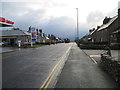
South Street (A952), Mintlaw
Looking south-eastward.
Image: © Peter Wood
Taken: 22 Nov 2019
0.23 miles
8
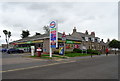
Service station and Post Office, on South Street, Mintlaw
Showing position of Postbox No. AB42 41.
See Image] for postbox.
Image: © JThomas
Taken: 22 Aug 2020
0.24 miles
9
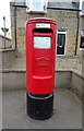
Elizabethan postbox on South Street, Mintlaw
Postbox No. AB42 41.
See Image] for context.
Image: © JThomas
Taken: 22 Aug 2020
0.24 miles